San Pedro geodata
San Pedro (Eastern Visayas) is a populated place; located in Philippines in Asia/Manila (GMT+8) time zone. With population of 3,603 people, there are 1978 cities with bigger population in this country. Compared to other cities in Philippines, 57.3% of cities are located further ↑North; 84.9% of cities are located further ←West and 92.8% of cities have lower elevation than San Pedro. Note1


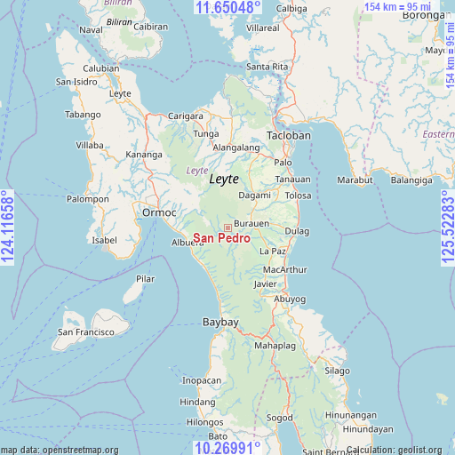
San Pedro GPS coordinates[2]
10° 57' 39.6" North, 124° 49' 10.92" East
| Map corner | latitude | longitude |
|---|---|---|
| Upper-left | 11.65048°, | 124.11658° |
| Center: | 10.961°, | 124.8197° |
| Lower-right: | 10.26991°, | 125.52283° |
| Map W x H: | 153.5×153.5 km | = 95.4×95.4mi |
| max Lat: | 20.78733° ⇑57.3% North |
| San Pedro: | 10.961° |
| min Lat: | ⇓42.7% South 4.65442° |
| min Long | San Pedro | max Long |
| 117.04868° | 124.8197° | 126.58417° |
| W 84.9%⇐ | ⇒15.1% E |
Elevation
Elevation of San Pedro is 321 m = 1053 ft, and this is 233.1 m = 765 ft above average elevation for this country.
| Max E: |
2262 m = 7421 ft | 7.2% |
| San Pedro | 321 m 1053 ft | |
| Avg. | 87.9 m = 288 ft | |
Min E: |
-2 m = -7 ft | 92.8% |
See also: Philippines elevation on elevation.city.
Geographical zone
San Pedro is located in North Torrid zone (between Equator and Tropic of Cancer). Distance of Equator is 1218.7 km =757.3 mi to South.| Distance of | km | miles | from San Pedro |
|---|---|---|---|
| North Pole | 8788.3 | 5460.8 | to North |
| Arctic Circle | 6182.4 | 3841.6 | to North |
| Tropic Cancer | 1387.2 | 862 | to North |
| Equator | 1218.7 | 757.3 | to South |


Nearby cities:
15 places around San Pedro: (largest is in red/bold)
• Albuera
14.6 km =9.1 mi,  249°
249°
• Balogo
14.5 km =9 mi,  235°
235°
• Burauen
8.1 km =5 mi,  78°
78°
• Cabacuñgan
17.9 km =11.1 mi,  99°
99°
• Canhandugan
19.8 km =12.3 mi,  347°
347°
• Caridad
16.2 km =10.1 mi,  207°
207°
• Dagami
14.3 km =8.9 mi,  39°
39°
• Ipil
20.1 km =12.5 mi,  274°
274°
• Julita
15.6 km =9.7 mi, 84°
• La Paz
16.7 km =10.4 mi,  117°
117°
• Mayorga
20.8 km =12.9 mi,  109°
109°
• Pastrana
20.8 km =12.9 mi,  20°
20°
• Siguinon
15.3 km =9.5 mi,  262°
262°
• Tabontabon
17.8 km =11.1 mi,  60°
60°
• Talisayan
13.1 km =8.1 mi, 264°
Sources, notices
• [Note1] Compared only with cities in Philippines existing in our database
• [Src1] Map data: © OpenStreetMap contributors (CC-BY-SA)
• [Src2] Other city data from geonames.org with taken over terms of usage.
• [Src3] Geographical zone / Annual Mean Temperature by Robert A. Rohde @ Wikipedia
