Caridad geodata
Caridad (Eastern Visayas) is a populated place; located in Philippines in Asia/Manila (GMT+8) time zone. With population of 3,688 people, there are 1926 cities with bigger population in this country. Compared to other cities in Philippines, 59% of cities are located further ↑North; 83.3% of cities are located further ←West and 85.4% of cities have higher elevation than Caridad. Note1
Administrative division(s):
- Level 1: Eastern Visayas
- Level 2: Province of Leyte
- Level 3: City of Baybay


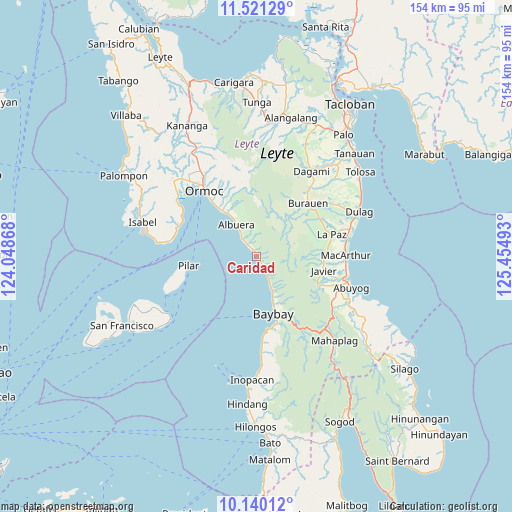
Caridad GPS coordinates[2]
10° 49' 53.4" North, 124° 45' 6.48" East
| Map corner | latitude | longitude |
|---|---|---|
| Upper-left | 11.52129°, | 124.04868° |
| Center: | 10.8315°, | 124.7518° |
| Lower-right: | 10.14012°, | 125.45493° |
| Map W x H: | 153.6×153.6 km | = 95.4×95.4mi |
| max Lat: | 20.78733° ⇑59% North |
| Caridad: | 10.8315° |
| min Lat: | ⇓41% South 4.65442° |
| min Long | Caridad | max Long |
| 117.04868° | 124.7518° | 126.58417° |
| W 83.3%⇐ | ⇒16.7% E |
Elevation
Elevation of Caridad is 8 m = 26 ft, and this is 79.9 m = 262 ft below average elevation for this country.
| Max E: |
2262 m = 7421 ft | 85.4% |
| Avg. | 87.9 m = 288 ft | |
| Caridad | 8 m = 26 ft | |
Min E: |
-2 m = -7 ft | 14.6% |
See also: Philippines elevation on elevation.city.
Geographical zone
Caridad is located in North Torrid zone (between Equator and Tropic of Cancer). Distance of Equator is 1204.3 km =748.3 mi to South.| Distance of | km | miles | from Caridad |
|---|---|---|---|
| North Pole | 8802.7 | 5469.7 | to North |
| Arctic Circle | 6196.8 | 3850.5 | to North |
| Tropic Cancer | 1401.6 | 870.9 | to North |
| Equator | 1204.3 | 748.3 | to South |


Nearby cities:
15 places around Caridad: (largest is in red/bold)
• Albuera
11.3 km =7 mi,  326°
326°
• Balogo
7.6 km =4.7 mi,  323°
323°
• Baybay
17.8 km =11.1 mi,  162°
162°
• Bugho
20.6 km =12.8 mi,  102°
102°
• Bunga
7.4 km =4.6 mi,  151°
151°
• Burauen
22.2 km =13.8 mi,  43°
43°
• Gabas
12.3 km =7.6 mi, 156°
• Hipasngo
19.8 km =12.3 mi, 161°
• Ipil
20.3 km =12.6 mi, 321°
• Kilim
14.2 km =8.8 mi, 159°
• Palhi
21.1 km =13.1 mi, 163°
• Pilar
20.5 km =12.7 mi,  262°
262°
• San Pedro
16.2 km =10.1 mi,  27°
27°
• Siguinon
14.6 km =9.1 mi, 327°
• Talisayan
14.3 km =8.9 mi,  336°
336°
Sources, notices
• [Note1] Compared only with cities in Philippines existing in our database
• [Src1] Map data: © OpenStreetMap contributors (CC-BY-SA)
• [Src2] Other city data from geonames.org with taken over terms of usage.
• [Src3] Geographical zone / Annual Mean Temperature by Robert A. Rohde @ Wikipedia
