San Pascual geodata
San Pascual (Bicol) is a seat of a third-order administrative division; located in Philippines in Asia/Manila (GMT+8) time zone. With population of 5,939 people, there are 1063 cities with bigger population in this country. Compared to other cities in Philippines, 58.2% of cities are located further ↓South; 52.8% of cities are located further ←West and 51.8% of cities have higher elevation than San Pascual. Note1


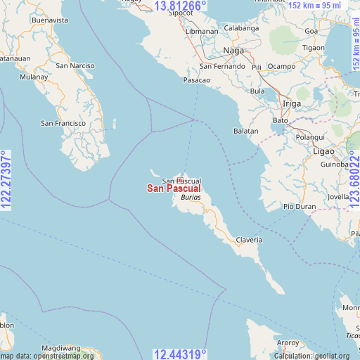
San Pascual GPS coordinates[2]
13° 7' 43.968" North, 122° 58' 37.524" East
| Map corner | latitude | longitude |
|---|---|---|
| Upper-left | 13.81266°, | 122.27397° |
| Center: | 13.12888°, | 122.97709° |
| Lower-right: | 12.44319°, | 123.68022° |
| Map W x H: | 152.3×152.3 km | = 94.6×94.6mi |
| max Lat: | 20.78733° ⇑41.8% North |
| San Pascual: | 13.12888° |
| min Lat: | ⇓58.2% South 4.65442° |
| min Long | San Pascual | max Long |
| 117.04868° | 122.97709° | 126.58417° |
| W 52.8%⇐ | ⇒47.2% E |
Elevation
Elevation of San Pascual is 22 m = 72 ft, and this is 65.9 m = 216 ft below average elevation for this country.
| Max E: |
2262 m = 7421 ft | 51.8% |
| Avg. | 87.9 m = 288 ft | |
| San Pascual | 22 m = 72 ft | |
Min E: |
-2 m = -7 ft | 48.2% |
See also: Philippines elevation on elevation.city.
Geographical zone
San Pascual is located in North Torrid zone (between Equator and Tropic of Cancer). Distance of this Northern Tropic circle is 1146.1 km =712.2 mi to North.| Distance of | km | miles | from San Pascual |
|---|---|---|---|
| North Pole | 8547.3 | 5311 | to North |
| Arctic Circle | 5941.4 | 3691.8 | to North |
| Tropic Cancer | 1146.1 | 712.2 | to North |
| Equator | 1459.8 | 907.1 | to South |


Nearby cities:
15 places around San Pascual: (largest is in red/bold)
• Apud
34.1 km =21.2 mi,  88°
88°
• Badian
37.4 km =23.2 mi,  106°
106°
• Balatan
35 km =21.7 mi,  52°
52°
• Busing
2.6 km =1.6 mi,  346°
346°
• Cagmanaba
35.6 km =22.1 mi,  103°
103°
• Claveria
38.4 km =23.9 mi,  130°
130°
• Macabugos
37.5 km =23.3 mi,  71°
71°
• Mangero
36.1 km =22.4 mi,  295°
295°
• Pansoy
41.3 km =25.7 mi,  278°
278°
• Pantao
38.6 km =24 mi,  79°
79°
• Salingogan
41.1 km =25.5 mi,  34°
34°
• San Andres
38.9 km =24.2 mi, 303°
• San Rafael
4.3 km =2.7 mi,  205°
205°
• Talisay
38.7 km =24 mi, 278°
• Tambo
36.7 km =22.8 mi, 67°
Sources, notices
• [Note1] Compared only with cities in Philippines existing in our database
• [Src1] Map data: © OpenStreetMap contributors (CC-BY-SA)
• [Src2] Other city data from geonames.org with taken over terms of usage.
• [Src3] Geographical zone / Annual Mean Temperature by Robert A. Rohde @ Wikipedia
