Apud geodata
Apud (Bicol) is a populated place; located in Philippines in Asia/Manila (GMT+8) time zone. With population of 2,071 people, there are 4116 cities with bigger population in this country. Compared to other cities in Philippines, 58.3% of cities are located further ↓South; 58.1% of cities are located further ←West and 80.7% of cities have higher elevation than Apud. Note1


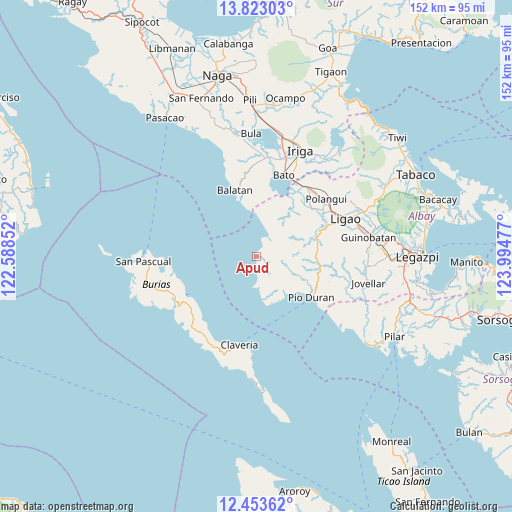
Apud GPS coordinates[2]
13° 8' 21.408" North, 123° 17' 29.904" East
| Map corner | latitude | longitude |
|---|---|---|
| Upper-left | 13.82303°, | 122.58852° |
| Center: | 13.13928°, | 123.29164° |
| Lower-right: | 12.45362°, | 123.99477° |
| Map W x H: | 152.3×152.3 km | = 94.6×94.6mi |
| max Lat: | 20.78733° ⇑41.7% North |
| Apud: | 13.13928° |
| min Lat: | ⇓58.3% South 4.65442° |
| min Long | Apud | max Long |
| 117.04868° | 123.29164° | 126.58417° |
| W 58.1%⇐ | ⇒41.9% E |
Elevation
Elevation of Apud is 9 m = 30 ft, and this is 78.9 m = 259 ft below average elevation for this country.
| Max E: |
2262 m = 7421 ft | 80.7% |
| Avg. | 87.9 m = 288 ft | |
| Apud | 9 m = 30 ft | |
Min E: |
-2 m = -7 ft | 19.3% |
See also: Philippines elevation on elevation.city.
Geographical zone
Apud is located in North Torrid zone (between Equator and Tropic of Cancer). Distance of this Northern Tropic circle is 1145 km =711.5 mi to North.| Distance of | km | miles | from Apud |
|---|---|---|---|
| North Pole | 8546.1 | 5310.3 | to North |
| Arctic Circle | 5940.2 | 3691.1 | to North |
| Tropic Cancer | 1145 | 711.5 | to North |
| Equator | 1461 | 907.8 | to South |


Nearby cities:
15 places around Apud: (largest is in red/bold)
• Badian
12.1 km =7.5 mi,  171°
171°
• Basicao Coastal
16 km =9.9 mi,  130°
130°
• Binodegahan
20 km =12.4 mi,  115°
115°
• Buga
19 km =11.8 mi,  22°
22°
• Buluang
19.4 km =12.1 mi, 16°
• Burabod
19.7 km =12.2 mi,  43°
43°
• Cagmanaba
9.4 km =5.8 mi,  176°
176°
• Del Rosario
18.7 km =11.6 mi,  7°
7°
• Macabugos
10.9 km =6.8 mi, 7°
• Maonon
14.3 km =8.9 mi,  143°
143°
• Pantao
7.2 km =4.5 mi,  32°
32°
• Paulba
19 km =11.8 mi,  76°
76°
• Sagrada Familia
18.4 km =11.4 mi, 38°
• San Jose
14.7 km =9.1 mi, 35°
• Tambo
12.9 km =8 mi,  359°
359°
Sources, notices
• [Note1] Compared only with cities in Philippines existing in our database
• [Src1] Map data: © OpenStreetMap contributors (CC-BY-SA)
• [Src2] Other city data from geonames.org with taken over terms of usage.
• [Src3] Geographical zone / Annual Mean Temperature by Robert A. Rohde @ Wikipedia
