Cawayan geodata
Cawayan (Calabarzon) is a populated place; located in Philippines in Asia/Manila (GMT+8) time zone. With population of 5,549 people, there are 1143 cities with bigger population in this country. Compared to other cities in Philippines, 60.9% of cities are located further ↓South; 54.6% of cities are located further →East and 73.2% of cities have higher elevation than Cawayan. Note1
Administrative division(s):
- Level 1: Calabarzon
- Level 2: Province of Quezon
- Level 3: San Francisco (Aurora)


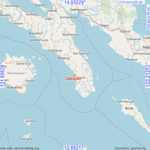
Cawayan GPS coordinates[2]
13° 22' 1.92" North, 122° 30' 33.84" East
| Map corner | latitude | longitude |
|---|---|---|
| Upper-left | 14.05029°, | 121.80628° |
| Center: | 13.3672°, | 122.5094° |
| Lower-right: | 12.68217°, | 123.21253° |
| Map W x H: | 152.1×152.1 km | = 94.5×94.5mi |
| max Lat: | 20.78733° ⇑39.1% North |
| Cawayan: | 13.3672° |
| min Lat: | ⇓60.9% South 4.65442° |
| min Long | Cawayan | max Long |
| 117.04868° | 122.5094° | 126.58417° |
| W 45.4%⇐ | ⇒54.6% E |
Elevation
Elevation of Cawayan is 11 m = 36 ft, and this is 76.9 m = 252 ft below average elevation for this country.
| Max E: |
2262 m = 7421 ft | 73.2% |
| Avg. | 87.9 m = 288 ft | |
| Cawayan | 11 m = 36 ft | |
Min E: |
-2 m = -7 ft | 26.8% |
See also: Philippines elevation on elevation.city.
Geographical zone
Cawayan is located in North Torrid zone (between Equator and Tropic of Cancer). Distance of this Northern Tropic circle is 1119.6 km =695.7 mi to North.| Distance of | km | miles | from Cawayan |
|---|---|---|---|
| North Pole | 8520.8 | 5294.6 | to North |
| Arctic Circle | 5914.9 | 3675.3 | to North |
| Tropic Cancer | 1119.6 | 695.7 | to North |
| Equator | 1486.3 | 923.5 | to South |


Nearby cities:
15 places around Cawayan: (largest is in red/bold)
• Aurora
2.4 km =1.5 mi,  153°
153°
• Binay
17.8 km =11.1 mi,  32°
32°
• Bosdak
3.8 km =2.4 mi,  344°
344°
• Camp Flora
16.8 km =10.4 mi,  96°
96°
• Casay
11.6 km =7.2 mi,  173°
173°
• Ibabang Tayuman
4.2 km =2.6 mi,  10°
10°
• Mangero
21.1 km =13.1 mi,  120°
120°
• Mulanay
20.7 km =12.9 mi,  326°
326°
• Pagsañgahan
17.2 km =10.7 mi, 167°
• Patabog
10.3 km =6.4 mi, 325°
• San Andres
18.9 km =11.7 mi,  105°
105°
• San Juan
19 km =11.8 mi,  24°
24°
• Silongin
7.6 km =4.7 mi, 169°
• Tala
13.2 km =8.2 mi,  141°
141°
• Yuni
5.7 km =3.5 mi, 331°
Sources, notices
• [Note1] Compared only with cities in Philippines existing in our database
• [Src1] Map data: © OpenStreetMap contributors (CC-BY-SA)
• [Src2] Other city data from geonames.org with taken over terms of usage.
• [Src3] Geographical zone / Annual Mean Temperature by Robert A. Rohde @ Wikipedia
