San Jose geodata
San Jose (Caraga) is a seat of a second-order administrative division; located in Philippines in Asia/Manila (GMT+8) time zone. In our database, there are 4166 cities with bigger population. Compared to other cities in Philippines, 66.4% of cities are located further ↑North; 94.2% of cities are located further ←West and 98.1% of cities have higher elevation than San Jose. Note1


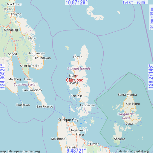
San Jose GPS coordinates[2]
10° 10' 48" North, 125° 34' 5.988" East
| Map corner | latitude | longitude |
|---|---|---|
| Upper-left | 10.87129°, | 124.86521° |
| Center: | 10.18°, | 125.56833° |
| Lower-right: | 9.48721°, | 126.27146° |
| Map W x H: | 153.9×153.9 km | = 95.6×95.6mi |
| max Lat: | 20.78733° ⇑66.4% North |
| San Jose: | 10.18° |
| min Lat: | ⇓33.6% South 4.65442° |
| min Long | San Jose | max Long |
| 117.04868° | 125.56833° | 126.58417° |
| W 94.2%⇐ | ⇒5.8% E |
Elevation
Elevation of San Jose is 3 m = 10 ft, and this is 84.9 m = 279 ft below average elevation for this country.
| Max E: |
2262 m = 7421 ft | 98.1% |
| Avg. | 87.9 m = 288 ft | |
| San Jose | 3 m = 10 ft | |
Min E: |
-2 m = -7 ft | 1.9% |
See also: Philippines elevation on elevation.city.
Geographical zone
San Jose is located in North Torrid zone (between Equator and Tropic of Cancer). Distance of Equator is 1131.9 km =703.3 mi to South.| Distance of | km | miles | from San Jose |
|---|---|---|---|
| North Pole | 8875.2 | 5514.8 | to North |
| Arctic Circle | 6269.3 | 3895.6 | to North |
| Tropic Cancer | 1474 | 915.9 | to North |
| Equator | 1131.9 | 703.3 | to South |


Nearby cities:
15 places around San Jose: (largest is in red/bold)
• Anahawan
35.2 km =21.9 mi,  287°
287°
• Basilisa
21.4 km =13.3 mi,  200°
200°
• Cagdianao
30.8 km =19.1 mi,  159°
159°
• Dinagat
25 km =15.5 mi,  173°
173°
• Hinundayan
39.7 km =24.7 mi,  298°
298°
• Libjo
4.1 km =2.5 mi, 298°
• Loreto
20.4 km =12.7 mi,  1°
1°
• Mabua
44.1 km =27.4 mi, 198°
• Pintuyan
43.7 km =27.2 mi,  233°
233°
• Saint Bernard
43.7 km =27.2 mi, 285°
• San Juan
44.1 km =27.4 mi,  282°
282°
• San Ricardo
43.6 km =27.1 mi, 227°
• Surigao
44.2 km =27.5 mi,  190°
190°
• Talisay
40.5 km =25.2 mi, 172°
• Tubajon
16.9 km =10.5 mi,  357°
357°
Sources, notices
• [Note1] Compared only with cities in Philippines existing in our database
• [Src1] Map data: © OpenStreetMap contributors (CC-BY-SA)
• [Src2] Other city data from geonames.org with taken over terms of usage.
• [Src3] Geographical zone / Annual Mean Temperature by Robert A. Rohde @ Wikipedia
