San Enrique geodata
San Enrique (Western Visayas) is a populated place; located in Philippines in Asia/Manila (GMT+8) time zone. With population of 2,620 people, there are 3076 cities with bigger population in this country. Compared to other cities in Philippines, 56.1% of cities are located further ↑North; 52.1% of cities are located further →East and 62.9% of cities have lower elevation than San Enrique. Note1
Administrative division(s):
- Level 1: Western Visayas
- Level 2: Province of Iloilo
- Level 3: San Enrique


San Enrique GPS coordinates[2]
11° 4' 16.32" North, 122° 39' 21.6" East
| Map corner | latitude | longitude |
|---|---|---|
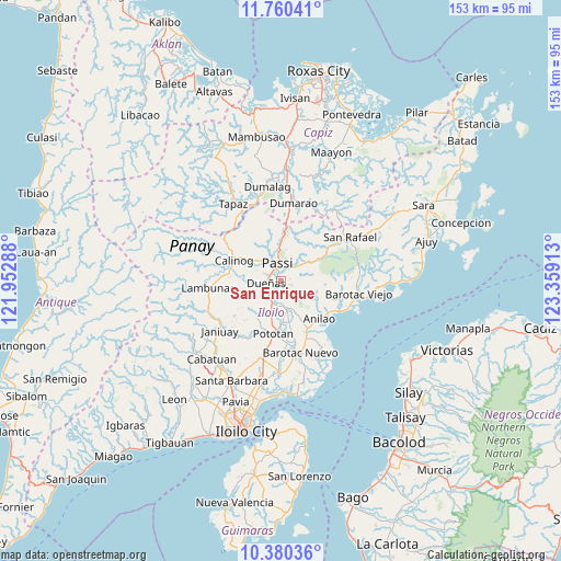
| Upper-left | 11.76041°, | 121.95288° |
| Center: | 11.0712°, | 122.656° |
| Lower-right: | 10.38036°, | 123.35913° |
| Map W x H: | 153.4×153.5 km | = 95.3×95.4mi |
| max Lat: | 20.78733° ⇑56.1% North |
| San Enrique: | 11.0712° |
| min Lat: | ⇓43.9% South 4.65442° |
| min Long | San Enrique | max Long |
| 117.04868° | 122.656° | 126.58417° |
| W 47.9%⇐ | ⇒52.1% E |
Elevation
Elevation of San Enrique is 38 m = 125 ft, and this is 49.9 m = 164 ft below average elevation for this country.
| Max E: |
2262 m = 7421 ft | 37.1% |
| Avg. | 87.9 m = 288 ft | |
| San Enrique | 38 m = 125 ft | |
Min E: |
-2 m = -7 ft | 62.9% |
See also: Philippines elevation on elevation.city.
Geographical zone
San Enrique is located in North Torrid zone (between Equator and Tropic of Cancer). Distance of Equator is 1231 km =764.9 mi to South.| Distance of | km | miles | from San Enrique |
|---|---|---|---|
| North Pole | 8776.1 | 5453.2 | to North |
| Arctic Circle | 6170.2 | 3834 | to North |
| Tropic Cancer | 1374.9 | 854.3 | to North |
| Equator | 1231 | 764.9 | to South |


Nearby cities:
15 places around San Enrique: (largest is in red/bold)
• Abaca
9.6 km =6 mi,  42°
42°
• Abangay
11.6 km =7.2 mi,  183°
183°
• Aglalana
12.1 km =7.5 mi,  0°
0°
• Alimono
14.1 km =8.8 mi,  26°
26°
• Calinog
11 km =6.8 mi,  297°
297°
• De la Paz
13.5 km =8.4 mi,  93°
93°
• Dingle
8.1 km =5 mi,  168°
168°
• Dueñas
4.4 km =2.7 mi,  263°
263°
• Jaguimitan
10.6 km =6.6 mi, 43°
• Libertad
13 km =8.1 mi,  107°
107°
• Mapili
10 km =6.2 mi,  65°
65°
• Maribong
13.8 km =8.6 mi,  283°
283°
• Passi
4.3 km =2.7 mi,  339°
339°
• Ponong
3.5 km =2.2 mi,  291°
291°
• Quinagaringan
9.4 km =5.8 mi,  307°
307°
Sources, notices
• [Note1] Compared only with cities in Philippines existing in our database
• [Src1] Map data: © OpenStreetMap contributors (CC-BY-SA)
• [Src2] Other city data from geonames.org with taken over terms of usage.
• [Src3] Geographical zone / Annual Mean Temperature by Robert A. Rohde @ Wikipedia
