Abaca geodata
Abaca (Western Visayas) is a populated place; located in Philippines in Asia/Manila (GMT+8) time zone. With population of 2,139 people, there are 4013 cities with bigger population in this country. Compared to other cities in Philippines, 55.4% of cities are located further ↑North; 51.2% of cities are located further →East and 75.3% of cities have lower elevation than Abaca. Note1
Administrative division(s):
- Level 1: Western Visayas
- Level 2: Province of Iloilo
- Level 3: San Enrique


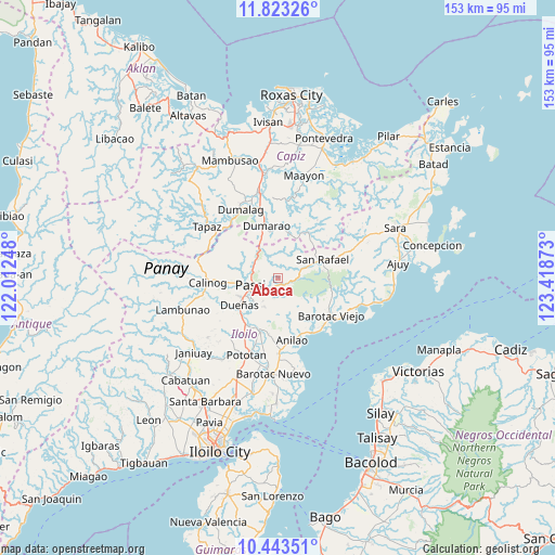
Abaca GPS coordinates[2]
11° 8' 3.12" North, 122° 42' 56.16" East
| Map corner | latitude | longitude |
|---|---|---|
| Upper-left | 11.82326°, | 122.01248° |
| Center: | 11.1342°, | 122.7156° |
| Lower-right: | 10.44351°, | 123.41873° |
| Map W x H: | 153.4×153.4 km | = 95.3×95.3mi |
| max Lat: | 20.78733° ⇑55.4% North |
| Abaca: | 11.1342° |
| min Lat: | ⇓44.6% South 4.65442° |
| min Long | Abaca | max Long |
| 117.04868° | 122.7156° | 126.58417° |
| W 48.8%⇐ | ⇒51.2% E |
Elevation
Elevation of Abaca is 69 m = 226 ft, and this is 18.9 m = 62 ft below average elevation for this country.
| Max E: |
2262 m = 7421 ft | 24.7% |
| Avg. | 87.9 m = 288 ft | |
| Abaca | 69 m = 226 ft | |
Min E: |
-2 m = -7 ft | 75.3% |
See also: Philippines elevation on elevation.city.
Geographical zone
Abaca is located in North Torrid zone (between Equator and Tropic of Cancer). Distance of Equator is 1238 km =769.3 mi to South.| Distance of | km | miles | from Abaca |
|---|---|---|---|
| North Pole | 8769.1 | 5448.9 | to North |
| Arctic Circle | 6163.2 | 3829.6 | to North |
| Tropic Cancer | 1367.9 | 850 | to North |
| Equator | 1238 | 769.3 | to South |


Nearby cities:
15 places around Abaca: (largest is in red/bold)
• Aglalana
8.2 km =5.1 mi,  308°
308°
• Alimono
5.7 km =3.5 mi,  357°
357°
• Bungsuan
12 km =7.5 mi,  350°
350°
• De la Paz
10.4 km =6.5 mi,  138°
138°
• Dueñas
13.2 km =8.2 mi,  235°
235°
• Dumarao
14.9 km =9.3 mi, 348°
• Gibato
14.8 km =9.2 mi,  46°
46°
• Jaguimitan
1.1 km =0.7 mi, 53°
• Libertad
12.5 km =7.8 mi,  151°
151°
• Mapili
3.9 km =2.4 mi, 138°
• Passi
8.6 km =5.3 mi,  249°
249°
• Ponong
11.3 km =7 mi, 239°
• Quinagaringan
14 km =8.7 mi,  264°
264°
• San Enrique
9.6 km =6 mi,  222°
222°
• San Rafael
13.1 km =8.1 mi,  68°
68°
Sources, notices
• [Note1] Compared only with cities in Philippines existing in our database
• [Src1] Map data: © OpenStreetMap contributors (CC-BY-SA)
• [Src2] Other city data from geonames.org with taken over terms of usage.
• [Src3] Geographical zone / Annual Mean Temperature by Robert A. Rohde @ Wikipedia
