Dueñas geodata
Dueñas (Western Visayas) is a seat of a third-order administrative division; located in Philippines in Asia/Manila (GMT+8) time zone. With population of 3,705 people, there are 1919 cities with bigger population in this country. Compared to other cities in Philippines, 56.1% of cities are located further ↑North; 52.8% of cities are located further →East and 69.6% of cities have lower elevation than Dueñas. Note1


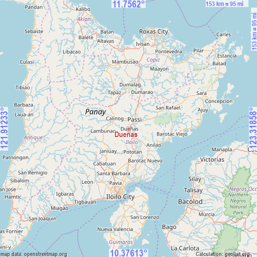
Dueñas GPS coordinates[2]
11° 4' 1.128" North, 122° 36' 55.62" East
| Map corner | latitude | longitude |
|---|---|---|
| Upper-left | 11.7562°, | 121.91233° |
| Center: | 11.06698°, | 122.61545° |
| Lower-right: | 10.37613°, | 123.31858° |
| Map W x H: | 153.4×153.5 km | = 95.3×95.4mi |
| max Lat: | 20.78733° ⇑56.1% North |
| Dueñas: | 11.06698° |
| min Lat: | ⇓43.9% South 4.65442° |
| min Long | Dueñas | max Long |
| 117.04868° | 122.61545° | 126.58417° |
| W 47.2%⇐ | ⇒52.8% E |
Elevation
Elevation of Dueñas is 51 m = 167 ft, and this is 36.9 m = 121 ft below average elevation for this country.
| Max E: |
2262 m = 7421 ft | 30.4% |
| Avg. | 87.9 m = 288 ft | |
| Dueñas | 51 m = 167 ft | |
Min E: |
-2 m = -7 ft | 69.6% |
See also: Philippines elevation on elevation.city.
Geographical zone
Dueñas is located in North Torrid zone (between Equator and Tropic of Cancer). Distance of Equator is 1230.5 km =764.6 mi to South.| Distance of | km | miles | from Dueñas |
|---|---|---|---|
| North Pole | 8776.5 | 5453.5 | to North |
| Arctic Circle | 6170.6 | 3834.2 | to North |
| Tropic Cancer | 1375.4 | 854.6 | to North |
| Equator | 1230.5 | 764.6 | to South |


Nearby cities:
15 places around Dueñas: (largest is in red/bold)
• Abaca
13.2 km =8.2 mi,  55°
55°
• Abangay
11.8 km =7.3 mi,  161°
161°
• Aglalana
13.4 km =8.3 mi,  19°
19°
• Badlan
13.3 km =8.3 mi,  308°
308°
• Binabaan
11.5 km =7.1 mi,  242°
242°
• Calinog
7.7 km =4.8 mi,  316°
316°
• Dingle
9.7 km =6 mi,  141°
141°
• Jaguimitan
14.3 km =8.9 mi, 55°
• Mapili
14.3 km =8.9 mi,  71°
71°
• Maribong
9.7 km =6 mi,  292°
292°
• Passi
5.4 km =3.4 mi,  32°
32°
• Ponong
2.1 km =1.3 mi, 33°
• Pototan
13.9 km =8.6 mi,  171°
171°
• Quinagaringan
6.9 km =4.3 mi,  333°
333°
• San Enrique
4.4 km =2.7 mi,  83°
83°
Sources, notices
• [Note1] Compared only with cities in Philippines existing in our database
• [Src1] Map data: © OpenStreetMap contributors (CC-BY-SA)
• [Src2] Other city data from geonames.org with taken over terms of usage.
• [Src3] Geographical zone / Annual Mean Temperature by Robert A. Rohde @ Wikipedia
