Aglalana geodata
Aglalana (Western Visayas) is a populated place; located in Philippines in Asia/Manila (GMT+8) time zone. With population of 2,868 people, there are 2681 cities with bigger population in this country. Compared to other cities in Philippines, 54.8% of cities are located further ↑North; 52% of cities are located further →East and 73.8% of cities have lower elevation than Aglalana. Note1
Administrative division(s):
- Level 1: Western Visayas
- Level 2: Province of Iloilo
- Level 3: City of Passi


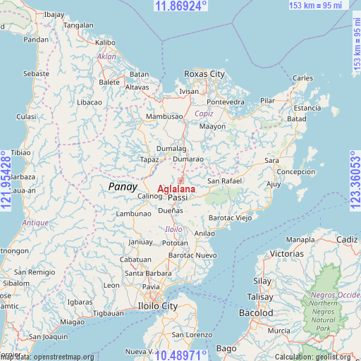
Aglalana GPS coordinates[2]
11° 10' 49.08" North, 122° 39' 26.64" East
| Map corner | latitude | longitude |
|---|---|---|
| Upper-left | 11.86924°, | 121.95428° |
| Center: | 11.1803°, | 122.6574° |
| Lower-right: | 10.48971°, | 123.36053° |
| Map W x H: | 153.4×153.4 km | = 95.3×95.3mi |
| max Lat: | 20.78733° ⇑54.8% North |
| Aglalana: | 11.1803° |
| min Lat: | ⇓45.2% South 4.65442° |
| min Long | Aglalana | max Long |
| 117.04868° | 122.6574° | 126.58417° |
| W 48%⇐ | ⇒52% E |
Elevation
Elevation of Aglalana is 64 m = 210 ft, and this is 23.9 m = 78 ft below average elevation for this country.
| Max E: |
2262 m = 7421 ft | 26.2% |
| Avg. | 87.9 m = 288 ft | |
| Aglalana | 64 m = 210 ft | |
Min E: |
-2 m = -7 ft | 73.8% |
See also: Philippines elevation on elevation.city.
Geographical zone
Aglalana is located in North Torrid zone (between Equator and Tropic of Cancer). Distance of Equator is 1243.1 km =772.4 mi to South.| Distance of | km | miles | from Aglalana |
|---|---|---|---|
| North Pole | 8763.9 | 5445.6 | to North |
| Arctic Circle | 6158 | 3826.4 | to North |
| Tropic Cancer | 1362.8 | 846.8 | to North |
| Equator | 1243.1 | 772.4 | to South |


Nearby cities:
15 places around Aglalana: (largest is in red/bold)
• Abaca
8.2 km =5.1 mi,  128°
128°
• Alimono
6.1 km =3.8 mi,  84°
84°
• Bingawan
11.5 km =7.1 mi,  300°
300°
• Bungsuan
8 km =5 mi,  33°
33°
• Calinog
12.2 km =7.6 mi,  234°
234°
• Dueñas
13.4 km =8.3 mi,  199°
199°
• Dumarao
10.1 km =6.3 mi,  19°
19°
• Duran
11.6 km =7.2 mi,  321°
321°
• Jaguimitan
8.5 km =5.3 mi,  121°
121°
• Mapili
12 km =7.5 mi, 131°
• Passi
8.2 km =5.1 mi,  191°
191°
• Ponong
11.4 km =7.1 mi, 197°
• Quinagaringan
10 km =6.2 mi, 229°
• San Enrique
12.1 km =7.5 mi,  180°
180°
• San Miguel
13.1 km =8.1 mi,  286°
286°
Sources, notices
• [Note1] Compared only with cities in Philippines existing in our database
• [Src1] Map data: © OpenStreetMap contributors (CC-BY-SA)
• [Src2] Other city data from geonames.org with taken over terms of usage.
• [Src3] Geographical zone / Annual Mean Temperature by Robert A. Rohde @ Wikipedia
