San Enrique geodata
San Enrique (Western Visayas) is a seat of a third-order administrative division; located in Philippines in Asia/Manila (GMT+8) time zone. In our database, there are 4166 cities with bigger population. Compared to other cities in Philippines, 61.5% of cities are located further ↑North; 51.2% of cities are located further →East and 76.6% of cities have higher elevation than San Enrique. Note1
Administrative division(s):
- Level 1: Western Visayas
- Level 2: Province of Guimaras
- Level 3: Buenavista


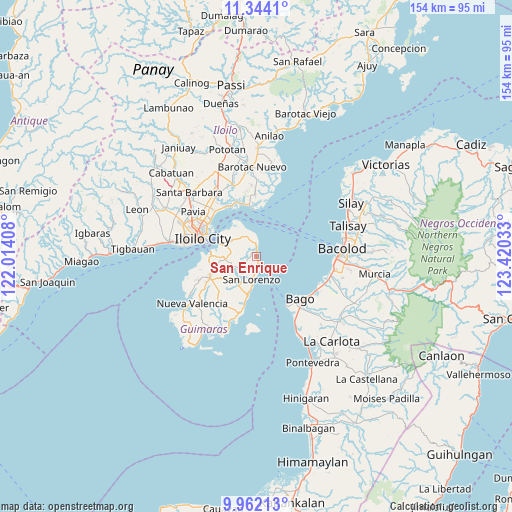
San Enrique GPS coordinates[2]
10° 39' 14.04" North, 122° 43' 1.92" East
| Map corner | latitude | longitude |
|---|---|---|
| Upper-left | 11.3441°, | 122.01408° |
| Center: | 10.6539°, | 122.7172° |
| Lower-right: | 9.96213°, | 123.42033° |
| Map W x H: | 153.7×153.7 km | = 95.5×95.5mi |
| max Lat: | 20.78733° ⇑61.5% North |
| San Enrique: | 10.6539° |
| min Lat: | ⇓38.5% South 4.65442° |
| min Long | San Enrique | max Long |
| 117.04868° | 122.7172° | 126.58417° |
| W 48.8%⇐ | ⇒51.2% E |
Elevation
Elevation of San Enrique is 10 m = 33 ft, and this is 77.9 m = 256 ft below average elevation for this country.
| Max E: |
2262 m = 7421 ft | 76.6% |
| Avg. | 87.9 m = 288 ft | |
| San Enrique | 10 m = 33 ft | |
Min E: |
-2 m = -7 ft | 23.4% |
See also: Philippines elevation on elevation.city.
Geographical zone
San Enrique is located in North Torrid zone (between Equator and Tropic of Cancer). Distance of Equator is 1184.6 km =736.1 mi to South.| Distance of | km | miles | from San Enrique |
|---|---|---|---|
| North Pole | 8822.5 | 5482 | to North |
| Arctic Circle | 6216.6 | 3862.8 | to North |
| Tropic Cancer | 1421.3 | 883.2 | to North |
| Equator | 1184.6 | 736.1 | to South |


Nearby cities:
15 places around San Enrique: (largest is in red/bold)
• Avila
4.3 km =2.7 mi,  348°
348°
• Bago City
18.5 km =11.5 mi,  136°
136°
• Buenavista
11.1 km =6.9 mi,  298°
298°
• Cabano
7.7 km =4.8 mi,  194°
194°
• Constancia
10.5 km =6.5 mi,  232°
232°
• East Valencia
1.8 km =1.1 mi,  333°
333°
• Getulio
11.8 km =7.3 mi, 331°
• Iloilo
17.4 km =10.8 mi,  285°
285°
• Jordan
13.2 km =8.2 mi,  272°
272°
• Morobuan
18 km =11.2 mi,  259°
259°
• Piña
8.8 km =5.5 mi, 259°
• Pulupandan
17.5 km =10.9 mi,  148°
148°
• Rizal
9.7 km =6 mi, 289°
• Salvacion
11.5 km =7.1 mi, 286°
• San Miguel
15.3 km =9.5 mi,  245°
245°
Sources, notices
• [Note1] Compared only with cities in Philippines existing in our database
• [Src1] Map data: © OpenStreetMap contributors (CC-BY-SA)
• [Src2] Other city data from geonames.org with taken over terms of usage.
• [Src3] Geographical zone / Annual Mean Temperature by Robert A. Rohde @ Wikipedia
