Getulio geodata
Getulio (Western Visayas) is a populated place; located in Philippines in Asia/Manila (GMT+8) time zone. With population of 2,063 people, there are 4123 cities with bigger population in this country. Compared to other cities in Philippines, 60.2% of cities are located further ↑North; 51.9% of cities are located further →East and 60.8% of cities have higher elevation than Getulio. Note1
Administrative division(s):
- Level 1: Western Visayas
- Level 2: Province of Guimaras
- Level 3: Buenavista


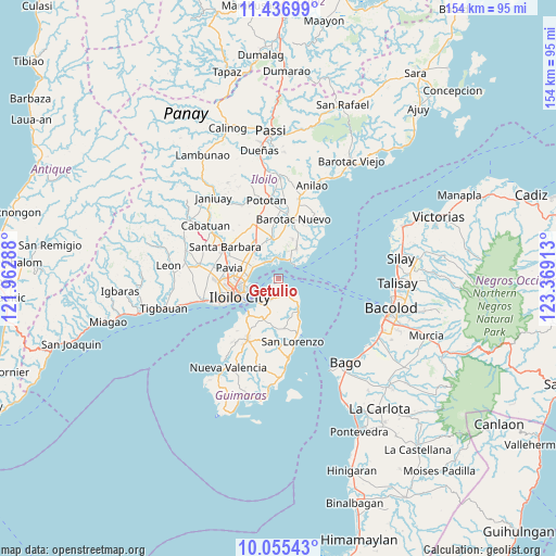
Getulio GPS coordinates[2]
10° 44' 49.2" North, 122° 39' 57.6" East
| Map corner | latitude | longitude |
|---|---|---|
| Upper-left | 11.43699°, | 121.96288° |
| Center: | 10.747°, | 122.666° |
| Lower-right: | 10.05543°, | 123.36913° |
| Map W x H: | 153.6×153.6 km | = 95.4×95.4mi |
| max Lat: | 20.78733° ⇑60.2% North |
| Getulio: | 10.747° |
| min Lat: | ⇓39.8% South 4.65442° |
| min Long | Getulio | max Long |
| 117.04868° | 122.666° | 126.58417° |
| W 48.1%⇐ | ⇒51.9% E |
Elevation
Elevation of Getulio is 16 m = 52 ft, and this is 71.9 m = 236 ft below average elevation for this country.
| Max E: |
2262 m = 7421 ft | 60.8% |
| Avg. | 87.9 m = 288 ft | |
| Getulio | 16 m = 52 ft | |
Min E: |
-2 m = -7 ft | 39.2% |
See also: Philippines elevation on elevation.city.
Geographical zone
Getulio is located in North Torrid zone (between Equator and Tropic of Cancer). Distance of Equator is 1195 km =742.5 mi to South.| Distance of | km | miles | from Getulio |
|---|---|---|---|
| North Pole | 8812.1 | 5475.6 | to North |
| Arctic Circle | 6206.2 | 3856.4 | to North |
| Tropic Cancer | 1411 | 876.8 | to North |
| Equator | 1195 | 742.5 | to South |


Nearby cities:
15 places around Getulio: (largest is in red/bold)
• Avila
7.7 km =4.8 mi,  142°
142°
• Buenavista
6.6 km =4.1 mi,  219°
219°
• Dumangas
10.1 km =6.3 mi,  30°
30°
• East Valencia
10 km =6.2 mi,  151°
151°
• Iloilo
12.4 km =7.7 mi,  243°
243°
• Jalaud
11.1 km =6.9 mi,  345°
345°
• Leganes
9.5 km =5.9 mi,  298°
298°
• Pasil
11.8 km =7.3 mi,  328°
328°
• Piña
12.3 km =7.6 mi,  194°
194°
• Rizal
7.9 km =4.9 mi,  206°
206°
• Salvacion
8.9 km =5.5 mi, 217°
• San Enrique
11.8 km =7.3 mi, 151°
• Sulangan
9.6 km =6 mi,  15°
15°
• Tigum
11.6 km =7.2 mi,  290°
290°
• Zarraga
10.3 km =6.4 mi,  321°
321°
Sources, notices
• [Note1] Compared only with cities in Philippines existing in our database
• [Src1] Map data: © OpenStreetMap contributors (CC-BY-SA)
• [Src2] Other city data from geonames.org with taken over terms of usage.
• [Src3] Geographical zone / Annual Mean Temperature by Robert A. Rohde @ Wikipedia
