San Vicente geodata
San Vicente (Eastern Visayas) is a seat of a third-order administrative division; located in Philippines in Asia/Manila (GMT+8) time zone. With population of 2,478 people, there are 3332 cities with bigger population in this country. Compared to other cities in Philippines, 53.2% of cities are located further ↓South; 72.8% of cities are located further ←West and 60.8% of cities have higher elevation than San Vicente. Note1
Administrative division(s):
- Level 1: Eastern Visayas
- Level 2: Province of Northern Samar
- Level 3: San Vicente


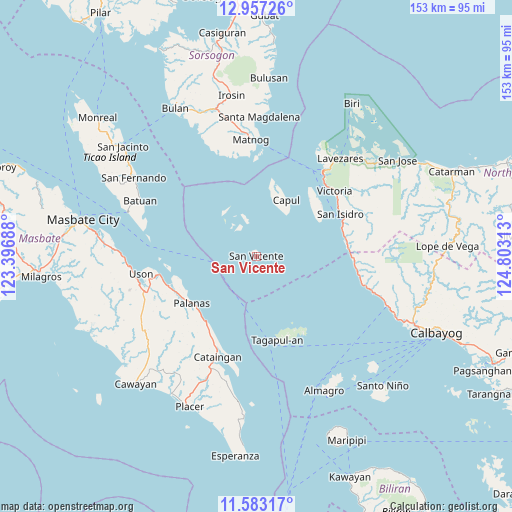
San Vicente GPS coordinates[2]
12° 16' 15.996" North, 124° 6' 0" East
| Map corner | latitude | longitude |
|---|---|---|
| Upper-left | 12.95726°, | 123.39688° |
| Center: | 12.27111°, | 124.1° |
| Lower-right: | 11.58317°, | 124.80313° |
| Map W x H: | 152.8×152.8 km | = 94.9×94.9mi |
| max Lat: | 20.78733° ⇑46.8% North |
| San Vicente: | 12.27111° |
| min Lat: | ⇓53.2% South 4.65442° |
| min Long | San Vicente | max Long |
| 117.04868° | 124.1° | 126.58417° |
| W 72.8%⇐ | ⇒27.2% E |
Elevation
Elevation of San Vicente is 16 m = 52 ft, and this is 71.9 m = 236 ft below average elevation for this country.
| Max E: |
2262 m = 7421 ft | 60.8% |
| Avg. | 87.9 m = 288 ft | |
| San Vicente | 16 m = 52 ft | |
Min E: |
-2 m = -7 ft | 39.2% |
See also: Philippines elevation on elevation.city.
Geographical zone
San Vicente is located in North Torrid zone (between Equator and Tropic of Cancer). Distance of this Northern Tropic circle is 1241.5 km =771.4 mi to North.| Distance of | km | miles | from San Vicente |
|---|---|---|---|
| North Pole | 8642.6 | 5370.3 | to North |
| Arctic Circle | 6036.8 | 3751.1 | to North |
| Tropic Cancer | 1241.5 | 771.4 | to North |
| Equator | 1364.4 | 847.8 | to South |


Nearby cities:
15 places around San Vicente: (largest is in red/bold)
• Alegria
28.3 km =17.6 mi,  60°
60°
• Balucawi
29 km =18 mi,  254°
254°
• Capul
19.1 km =11.9 mi,  27°
27°
• Dimasalang
27.6 km =17.1 mi, 251°
• Erenas
29.7 km =18.5 mi,  54°
54°
• Nabangig
25.1 km =15.6 mi,  220°
220°
• Palanas
23.9 km =14.9 mi,  234°
234°
• Palanit
27 km =16.8 mi,  78°
78°
• Pawican
26 km =16.2 mi,  212°
212°
• Peña
26.8 km =16.7 mi, 220°
• San Antonio
25 km =15.5 mi, 50°
• San Isidro
28.3 km =17.6 mi, 62°
• Tagapul-an
25.2 km =15.7 mi,  167°
167°
• Victoria
30.2 km =18.8 mi, 49°
• Viriato
27.6 km =17.1 mi,  85°
85°
Sources, notices
• [Note1] Compared only with cities in Philippines existing in our database
• [Src1] Map data: © OpenStreetMap contributors (CC-BY-SA)
• [Src2] Other city data from geonames.org with taken over terms of usage.
• [Src3] Geographical zone / Annual Mean Temperature by Robert A. Rohde @ Wikipedia
