San Alfonso geodata
San Alfonso (Davao) is a populated place; located in Philippines in Asia/Manila (GMT+8) time zone. With population of 3,386 people, there are 2150 cities with bigger population in this country. Compared to other cities in Philippines, 84.5% of cities are located further ↑North; 99.6% of cities are located further ←West and 56.6% of cities have lower elevation than San Alfonso. Note1


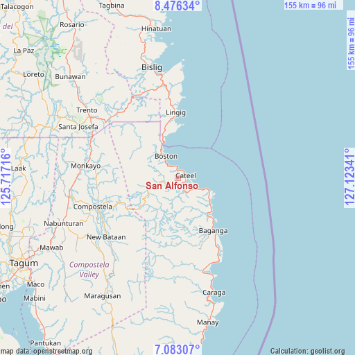
San Alfonso GPS coordinates[2]
7° 46' 49.008" North, 126° 25' 13.008" East
| Map corner | latitude | longitude |
|---|---|---|
| Upper-left | 8.47634°, | 125.71716° |
| Center: | 7.78028°, | 126.42028° |
| Lower-right: | 7.08307°, | 127.12341° |
| Map W x H: | 154.9×154.9 km | = 96.3×96.3mi |
| max Lat: | 20.78733° ⇑84.5% North |
| San Alfonso: | 7.78028° |
| min Lat: | ⇓15.5% South 4.65442° |
| min Long | San Alfonso | max Long |
| 117.04868° | 126.42028° | 126.58417° |
| W 99.6%⇐ | ⇒0.40000000000001% E |
Elevation
Elevation of San Alfonso is 29 m = 95 ft, and this is 58.9 m = 193 ft below average elevation for this country.
| Max E: |
2262 m = 7421 ft | 43.4% |
| Avg. | 87.9 m = 288 ft | |
| San Alfonso | 29 m = 95 ft | |
Min E: |
-2 m = -7 ft | 56.6% |
See also: Philippines elevation on elevation.city.
Geographical zone
San Alfonso is located in North Torrid zone (between Equator and Tropic of Cancer). Distance of Equator is 865.1 km =537.5 mi to South.| Distance of | km | miles | from San Alfonso |
|---|---|---|---|
| North Pole | 9142 | 5680.6 | to North |
| Arctic Circle | 6536.1 | 4061.3 | to North |
| Tropic Cancer | 1740.8 | 1081.7 | to North |
| Equator | 865.1 | 537.5 | to South |


Nearby cities:
15 places around San Alfonso: (largest is in red/bold)
• Babag
38.8 km =24.1 mi,  262°
262°
• Baganga
27.6 km =17.1 mi,  146°
146°
• Bantacan
37.5 km =23.3 mi,  238°
238°
• Batiano
26.4 km =16.4 mi,  162°
162°
• Boston
11.8 km =7.3 mi,  328°
328°
• Cateel
3.8 km =2.4 mi,  71°
71°
• Compostela
38.4 km =23.9 mi,  251°
251°
• Kinablangan
17.2 km =10.7 mi,  124°
124°
• Lingig
28.8 km =17.9 mi,  358°
358°
• Mahanob
24.9 km =15.5 mi, 157°
• San Luis
40.3 km =25 mi, 159°
• San Rafael
4.3 km =2.7 mi,  114°
114°
• Santa Maria
23.7 km =14.7 mi,  6°
6°
• Santa Maria
40 km =24.9 mi,  314°
314°
• Taytayan
10.4 km =6.5 mi, 119°
Sources, notices
• [Note1] Compared only with cities in Philippines existing in our database
• [Src1] Map data: © OpenStreetMap contributors (CC-BY-SA)
• [Src2] Other city data from geonames.org with taken over terms of usage.
• [Src3] Geographical zone / Annual Mean Temperature by Robert A. Rohde @ Wikipedia
