Lingig geodata
Lingig (Caraga) is a seat of a third-order administrative division; located in Philippines in Asia/Manila (GMT+8) time zone. With population of 6,400 people, there are 977 cities with bigger population in this country. Compared to other cities in Philippines, 82.3% of cities are located further ↑North; 99.6% of cities are located further ←West and 85.4% of cities have higher elevation than Lingig. Note1


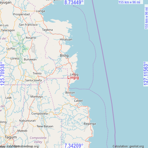
Lingig GPS coordinates[2]
8° 2' 20.004" North, 126° 24' 45" East
| Map corner | latitude | longitude |
|---|---|---|
| Upper-left | 8.73449°, | 125.70938° |
| Center: | 8.03889°, | 126.4125° |
| Lower-right: | 7.34209°, | 127.11563° |
| Map W x H: | 154.8×154.8 km | = 96.2×96.2mi |
| max Lat: | 20.78733° ⇑82.3% North |
| Lingig: | 8.03889° |
| min Lat: | ⇓17.7% South 4.65442° |
| min Long | Lingig | max Long |
| 117.04868° | 126.4125° | 126.58417° |
| W 99.6%⇐ | ⇒0.40000000000001% E |
Elevation
Elevation of Lingig is 8 m = 26 ft, and this is 79.9 m = 262 ft below average elevation for this country.
| Max E: |
2262 m = 7421 ft | 85.4% |
| Avg. | 87.9 m = 288 ft | |
| Lingig | 8 m = 26 ft | |
Min E: |
-2 m = -7 ft | 14.6% |
See also: Philippines elevation on elevation.city.
Geographical zone
Lingig is located in North Torrid zone (between Equator and Tropic of Cancer). Distance of Equator is 893.8 km =555.4 mi to South.| Distance of | km | miles | from Lingig |
|---|---|---|---|
| North Pole | 9113.2 | 5662.7 | to North |
| Arctic Circle | 6507.3 | 4043.4 | to North |
| Tropic Cancer | 1712.1 | 1063.8 | to North |
| Equator | 893.8 | 555.4 | to South |


Nearby cities:
15 places around Lingig: (largest is in red/bold)
• Barcelona
13.6 km =8.5 mi,  10°
10°
• Bigaan
34.2 km =21.3 mi,  334°
334°
• Bislig
22.3 km =13.9 mi, 331°
• Boston
19.4 km =12.1 mi,  195°
195°
• Cateel
27.9 km =17.3 mi,  170°
170°
• Cuevas
35.1 km =21.8 mi,  266°
266°
• Hinatuan
38.1 km =23.7 mi,  346°
346°
• Loyola
34 km =21.1 mi, 345°
• Salvacion
32 km =19.9 mi,  262°
262°
• San Alfonso
28.8 km =17.9 mi,  178°
178°
• San Rafael
30.9 km =19.2 mi, 171°
• Santa Maria
6.4 km =4 mi,  145°
145°
• Santa Maria
27.5 km =17.1 mi, 268°
• Taytayan
35.3 km =21.9 mi,  163°
163°
• Tidman
30 km =18.6 mi,  344°
344°
Sources, notices
• [Note1] Compared only with cities in Philippines existing in our database
• [Src1] Map data: © OpenStreetMap contributors (CC-BY-SA)
• [Src2] Other city data from geonames.org with taken over terms of usage.
• [Src3] Geographical zone / Annual Mean Temperature by Robert A. Rohde @ Wikipedia
