Santa Maria geodata
Santa Maria (Caraga) is a populated place; located in Philippines in Asia/Manila (GMT+8) time zone. With population of 2,354 people, there are 3552 cities with bigger population in this country. Compared to other cities in Philippines, 82.9% of cities are located further ↑North; 99.6% of cities are located further ←West and 66.7% of cities have lower elevation than Santa Maria. Note1


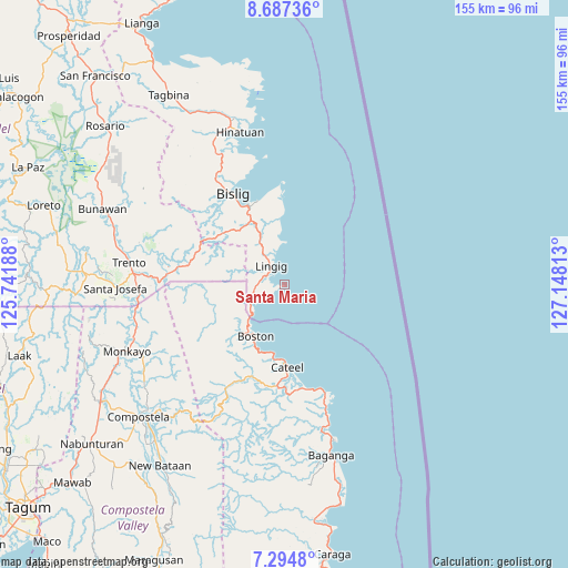
Santa Maria GPS coordinates[2]
7° 59' 30.012" North, 126° 26' 42" East
| Map corner | latitude | longitude |
|---|---|---|
| Upper-left | 8.68736°, | 125.74188° |
| Center: | 7.99167°, | 126.445° |
| Lower-right: | 7.2948°, | 127.14813° |
| Map W x H: | 154.8×154.8 km | = 96.2×96.2mi |
| max Lat: | 20.78733° ⇑82.9% North |
| Santa Maria: | 7.99167° |
| min Lat: | ⇓17.1% South 4.65442° |
| min Long | Santa Maria | max Long |
| 117.04868° | 126.445° | 126.58417° |
| W 99.6%⇐ | ⇒0.40000000000001% E |
Elevation
Elevation of Santa Maria is 45 m = 148 ft, and this is 42.9 m = 141 ft below average elevation for this country.
| Max E: |
2262 m = 7421 ft | 33.3% |
| Avg. | 87.9 m = 288 ft | |
| Santa Maria | 45 m = 148 ft | |
Min E: |
-2 m = -7 ft | 66.7% |
See also: Philippines elevation on elevation.city.
Geographical zone
Santa Maria is located in North Torrid zone (between Equator and Tropic of Cancer). Distance of Equator is 888.6 km =552.2 mi to South.| Distance of | km | miles | from Santa Maria |
|---|---|---|---|
| North Pole | 9118.5 | 5666 | to North |
| Arctic Circle | 6512.6 | 4046.7 | to North |
| Tropic Cancer | 1717.3 | 1067.1 | to North |
| Equator | 888.6 | 552.2 | to South |


Nearby cities:
15 places around Santa Maria: (largest is in red/bold)
• Barcelona
18.7 km =11.6 mi,  356°
356°
• Bigaan
40.4 km =25.1 mi,  333°
333°
• Bislig
28.6 km =17.8 mi, 330°
• Boston
16.1 km =10 mi,  213°
213°
• Cateel
22.3 km =13.9 mi,  177°
177°
• Cuevas
38.7 km =24 mi,  274°
274°
• Kinablangan
35.2 km =21.9 mi,  160°
160°
• Lingig
6.4 km =4 mi, 325°
• Loyola
40.1 km =24.9 mi,  342°
342°
• Salvacion
35.3 km =21.9 mi, 271°
• San Alfonso
23.7 km =14.7 mi,  186°
186°
• San Rafael
25.4 km =15.8 mi, 177°
• Santa Maria
31.4 km =19.5 mi,  278°
278°
• Taytayan
29.3 km =18.2 mi,  167°
167°
• Tidman
36.1 km =22.4 mi, 341°
Sources, notices
• [Note1] Compared only with cities in Philippines existing in our database
• [Src1] Map data: © OpenStreetMap contributors (CC-BY-SA)
• [Src2] Other city data from geonames.org with taken over terms of usage.
• [Src3] Geographical zone / Annual Mean Temperature by Robert A. Rohde @ Wikipedia
