Boston geodata
Boston (Davao) is a populated place; located in Philippines in Asia/Manila (GMT+8) time zone. With population of 2,891 people, there are 2657 cities with bigger population in this country. Compared to other cities in Philippines, 83.6% of cities are located further ↑North; 99.5% of cities are located further ←West and 53.1% of cities have higher elevation than Boston. Note1


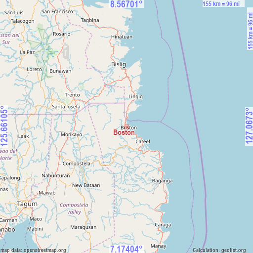
Boston GPS coordinates[2]
7° 52' 15.996" North, 126° 21' 51.012" East
| Map corner | latitude | longitude |
|---|---|---|
| Upper-left | 8.56701°, | 125.66105° |
| Center: | 7.87111°, | 126.36417° |
| Lower-right: | 7.17404°, | 127.0673° |
| Map W x H: | 154.9×154.9 km | = 96.3×96.3mi |
| max Lat: | 20.78733° ⇑83.6% North |
| Boston: | 7.87111° |
| min Lat: | ⇓16.4% South 4.65442° |
| min Long | Boston | max Long |
| 117.04868° | 126.36417° | 126.58417° |
| W 99.5%⇐ | ⇒0.5% E |
Elevation
Elevation of Boston is 21 m = 69 ft, and this is 66.9 m = 219 ft below average elevation for this country.
| Max E: |
2262 m = 7421 ft | 53.1% |
| Avg. | 87.9 m = 288 ft | |
| Boston | 21 m = 69 ft | |
Min E: |
-2 m = -7 ft | 46.9% |
See also: Philippines elevation on elevation.city.
Geographical zone
Boston is located in North Torrid zone (between Equator and Tropic of Cancer). Distance of Equator is 875.2 km =543.8 mi to South.| Distance of | km | miles | from Boston |
|---|---|---|---|
| North Pole | 9131.9 | 5674.3 | to North |
| Arctic Circle | 6526 | 4055.1 | to North |
| Tropic Cancer | 1730.7 | 1075.4 | to North |
| Equator | 875.2 | 543.8 | to South |


Nearby cities:
15 places around Boston: (largest is in red/bold)
• Babag
35.7 km =22.2 mi,  244°
244°
• Barcelona
32.9 km =20.4 mi,  13°
13°
• Baylo
34 km =21.1 mi,  267°
267°
• Cateel
13.2 km =8.2 mi,  132°
132°
• Cuevas
34 km =21.1 mi,  298°
298°
• Kinablangan
28.4 km =17.6 mi, 134°
• Lingig
19.4 km =12.1 mi,  15°
15°
• Monkayo
34.7 km =21.6 mi,  259°
259°
• Pasian
33.3 km =20.7 mi,  280°
280°
• Salvacion
30 km =18.6 mi, 298°
• San Alfonso
11.8 km =7.3 mi,  148°
148°
• San Rafael
15.6 km =9.7 mi,  139°
139°
• Santa Maria
16.1 km =10 mi,  33°
33°
• Santa Maria
28.6 km =17.8 mi,  309°
309°
• Taytayan
21.5 km =13.4 mi, 135°
Sources, notices
• [Note1] Compared only with cities in Philippines existing in our database
• [Src1] Map data: © OpenStreetMap contributors (CC-BY-SA)
• [Src2] Other city data from geonames.org with taken over terms of usage.
• [Src3] Geographical zone / Annual Mean Temperature by Robert A. Rohde @ Wikipedia
