Bantacan geodata
Bantacan (Davao) is a populated place; located in Philippines in Asia/Manila (GMT+8) time zone. With population of 3,299 people, there are 2219 cities with bigger population in this country. Compared to other cities in Philippines, 85.9% of cities are located further ↑North; 98.8% of cities are located further ←West and 82.6% of cities have lower elevation than Bantacan. Note1


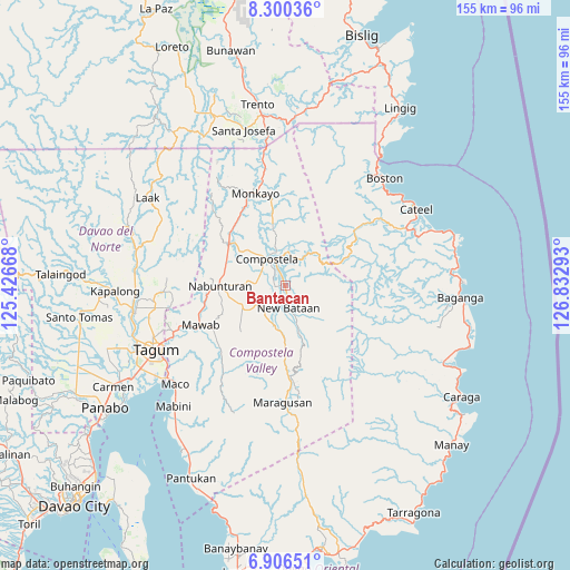
Bantacan GPS coordinates[2]
7° 36' 14.4" North, 126° 7' 47.28" East
| Map corner | latitude | longitude |
|---|---|---|
| Upper-left | 8.30036°, | 125.42668° |
| Center: | 7.604°, | 126.1298° |
| Lower-right: | 6.90651°, | 126.83293° |
| Map W x H: | 155×155 km | = 96.3×96.3mi |
| max Lat: | 20.78733° ⇑85.9% North |
| Bantacan: | 7.604° |
| min Lat: | ⇓14.1% South 4.65442° |
| min Long | Bantacan | max Long |
| 117.04868° | 126.1298° | 126.58417° |
| W 98.8%⇐ | ⇒1.2% E |
Elevation
Elevation of Bantacan is 112 m = 367 ft, and this is 24.1 m = 79 ft above average elevation for this country.
| Max E: |
2262 m = 7421 ft | 17.4% |
| Bantacan | 112 m 367 ft | |
| Avg. | 87.9 m = 288 ft | |
Min E: |
-2 m = -7 ft | 82.6% |
See also: Philippines elevation on elevation.city.
Geographical zone
Bantacan is located in North Torrid zone (between Equator and Tropic of Cancer). Distance of Equator is 845.5 km =525.4 mi to South.| Distance of | km | miles | from Bantacan |
|---|---|---|---|
| North Pole | 9161.6 | 5692.8 | to North |
| Arctic Circle | 6555.7 | 4073.5 | to North |
| Tropic Cancer | 1760.4 | 1093.9 | to North |
| Equator | 845.5 | 525.4 | to South |


Nearby cities:
15 places around Bantacan: (largest is in red/bold)
• Andili
23.6 km =14.7 mi,  228°
228°
• Babag
15.7 km =9.8 mi,  335°
335°
• Cabinuangan
13.8 km =8.6 mi,  309°
309°
• Compostela
8.9 km =5.5 mi,  329°
329°
• Gabi
4.6 km =2.9 mi,  295°
295°
• Linoan
17.3 km =10.7 mi,  278°
278°
• Manat
13.1 km =8.1 mi,  249°
249°
• Manat
14.7 km =9.1 mi,  237°
237°
• Mawab
16.7 km =10.4 mi,  255°
255°
• Monkayo
24.9 km =15.5 mi, 340°
• Montevista
18.4 km =11.4 mi, 302°
• Nabunturan
18 km =11.2 mi,  271°
271°
• New Sibonga
22.6 km =14 mi, 257°
• San Mariano
18.4 km =11.4 mi, 231°
• Tapia
21.2 km =13.2 mi,  322°
322°
Sources, notices
• [Note1] Compared only with cities in Philippines existing in our database
• [Src1] Map data: © OpenStreetMap contributors (CC-BY-SA)
• [Src2] Other city data from geonames.org with taken over terms of usage.
• [Src3] Geographical zone / Annual Mean Temperature by Robert A. Rohde @ Wikipedia
