San Casimiro geodata
San Casimiro (Central Luzon) is a populated place; located in Philippines in Asia/Manila (GMT+8) time zone. With population of 2,833 people, there are 2735 cities with bigger population in this country. Compared to other cities in Philippines, 82.2% of cities are located further ↓South; 82.8% of cities are located further →East and 55.6% of cities have lower elevation than San Casimiro. Note1


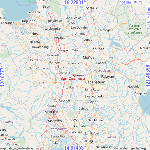
San Casimiro GPS coordinates[2]
15° 33' 11.016" North, 120° 46' 50.988" East
| Map corner | latitude | longitude |
|---|---|---|
| Upper-left | 16.22931°, | 120.07771° |
| Center: | 15.55306°, | 120.78083° |
| Lower-right: | 14.87458°, | 121.48396° |
| Map W x H: | 150.6×150.6 km | = 93.6×93.6mi |
| max Lat: | 20.78733° ⇑17.8% North |
| San Casimiro: | 15.55306° |
| min Lat: | ⇓82.2% South 4.65442° |
| min Long | San Casimiro | max Long |
| 117.04868° | 120.78083° | 126.58417° |
| W 17.2%⇐ | ⇒82.8% E |
Elevation
Elevation of San Casimiro is 28 m = 92 ft, and this is 59.9 m = 197 ft below average elevation for this country.
| Max E: |
2262 m = 7421 ft | 44.4% |
| Avg. | 87.9 m = 288 ft | |
| San Casimiro | 28 m = 92 ft | |
Min E: |
-2 m = -7 ft | 55.6% |
See also: Philippines elevation on elevation.city.
Geographical zone
San Casimiro is located in North Torrid zone (between Equator and Tropic of Cancer). Distance of this Northern Tropic circle is 876.6 km =544.7 mi to North.| Distance of | km | miles | from San Casimiro |
|---|---|---|---|
| North Pole | 8277.7 | 5143.5 | to North |
| Arctic Circle | 5671.8 | 3524.3 | to North |
| Tropic Cancer | 876.6 | 544.7 | to North |
| Equator | 1729.3 | 1074.5 | to South |


Nearby cities:
15 places around San Casimiro: (largest is in red/bold)
• Aliaga
8.9 km =5.5 mi,  131°
131°
• Balayang
9.3 km =5.8 mi,  267°
267°
• Bibiclat
9.4 km =5.8 mi,  111°
111°
• Calibungan
7.9 km =4.9 mi,  309°
309°
• Cawayan Bugtong
9 km =5.6 mi,  357°
357°
• Licab
2.1 km =1.3 mi,  241°
241°
• Manacsac
4.8 km =3 mi,  13°
13°
• Matayumtayum
8.6 km =5.3 mi, 241°
• Nagpandayan
5.5 km =3.4 mi,  346°
346°
• Quezon
3.6 km =2.2 mi,  93°
93°
• San Alejandro
7.4 km =4.6 mi,  83°
83°
• San Cristobal
1.5 km =0.9 mi, 273°
• Santa Lucia
7.9 km =4.9 mi,  184°
184°
• Santa Maria
3.5 km =2.2 mi,  159°
159°
• Villarosa
3.3 km =2.1 mi,  264°
264°
Sources, notices
• [Note1] Compared only with cities in Philippines existing in our database
• [Src1] Map data: © OpenStreetMap contributors (CC-BY-SA)
• [Src2] Other city data from geonames.org with taken over terms of usage.
• [Src3] Geographical zone / Annual Mean Temperature by Robert A. Rohde @ Wikipedia
