Salvacion geodata
Salvacion (Caraga) is a populated place; located in Philippines in Asia/Manila (GMT+8) time zone. With population of 2,088 people, there are 4090 cities with bigger population in this country. Compared to other cities in Philippines, 77.2% of cities are located further ↑North; 99.1% of cities are located further ←West and 62.8% of cities have higher elevation than Salvacion. Note1
Administrative division(s):
- Level 1: Caraga
- Level 2: Province of Surigao del Sur
- Level 3: San Agustin


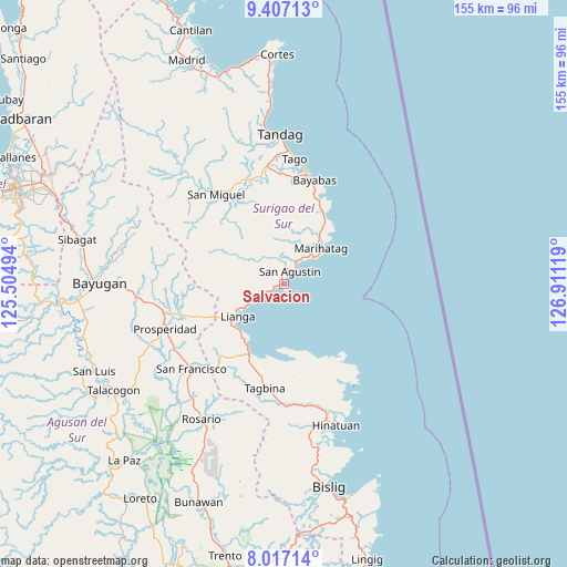
Salvacion GPS coordinates[2]
8° 42' 46.008" North, 126° 12' 29.016" East
| Map corner | latitude | longitude |
|---|---|---|
| Upper-left | 9.40713°, | 125.50494° |
| Center: | 8.71278°, | 126.20806° |
| Lower-right: | 8.01714°, | 126.91119° |
| Map W x H: | 154.6×154.6 km | = 96.1×96.1mi |
| max Lat: | 20.78733° ⇑77.2% North |
| Salvacion: | 8.71278° |
| min Lat: | ⇓22.8% South 4.65442° |
| min Long | Salvacion | max Long |
| 117.04868° | 126.20806° | 126.58417° |
| W 99.1%⇐ | ⇒0.90000000000001% E |
Elevation
Elevation of Salvacion is 15 m = 49 ft, and this is 72.9 m = 239 ft below average elevation for this country.
| Max E: |
2262 m = 7421 ft | 62.8% |
| Avg. | 87.9 m = 288 ft | |
| Salvacion | 15 m = 49 ft | |
Min E: |
-2 m = -7 ft | 37.2% |
See also: Philippines elevation on elevation.city.
Geographical zone
Salvacion is located in North Torrid zone (between Equator and Tropic of Cancer). Distance of Equator is 968.8 km =602 mi to South.| Distance of | km | miles | from Salvacion |
|---|---|---|---|
| North Pole | 9038.3 | 5616.1 | to North |
| Arctic Circle | 6432.4 | 3996.9 | to North |
| Tropic Cancer | 1637.1 | 1017.2 | to North |
| Equator | 968.8 | 602 | to South |


Nearby cities:
15 places around Salvacion: (largest is in red/bold)
• Alegria
31.5 km =19.6 mi,  223°
223°
• Amaga
25.3 km =15.7 mi, 216°
• Aras-asan
22.5 km =14 mi,  30°
30°
• Bacolod
25.9 km =16.1 mi,  20°
20°
• Barobo
21.9 km =13.6 mi,  205°
205°
• Bayabas
29.8 km =18.5 mi, 16°
• Cagwait
25.1 km =15.6 mi, 24°
• Gamut
20.5 km =12.7 mi,  169°
169°
• Javier
28.3 km =17.6 mi, 208°
• La Paz
30.8 km =19.1 mi,  11°
11°
• Lianga
15.3 km =9.5 mi,  234°
234°
• Los Arcos
26 km =16.2 mi,  250°
250°
• Marihatag
14.2 km =8.8 mi,  43°
43°
• Tagbina
29.3 km =18.2 mi,  187°
187°
• Unidad
19.8 km =12.3 mi, 173°
Sources, notices
• [Note1] Compared only with cities in Philippines existing in our database
• [Src1] Map data: © OpenStreetMap contributors (CC-BY-SA)
• [Src2] Other city data from geonames.org with taken over terms of usage.
• [Src3] Geographical zone / Annual Mean Temperature by Robert A. Rohde @ Wikipedia
