Bacolod geodata
Bacolod (Caraga) is a populated place; located in Philippines in Asia/Manila (GMT+8) time zone. With population of 2,171 people, there are 3949 cities with bigger population in this country. Compared to other cities in Philippines, 76.3% of cities are located further ↑North; 99.3% of cities are located further ←West and 73.1% of cities have lower elevation than Bacolod. Note1


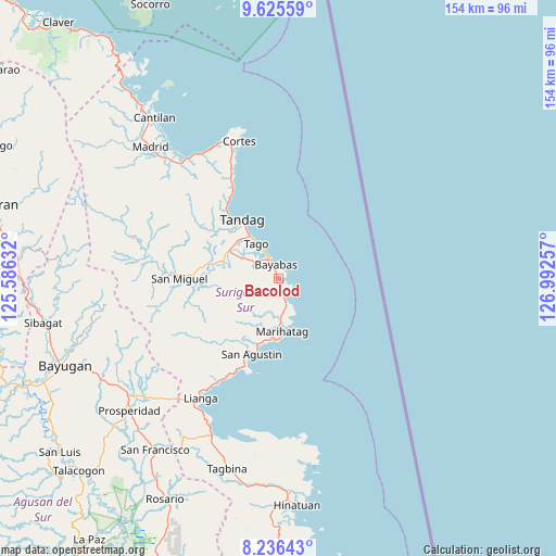
Bacolod GPS coordinates[2]
8° 55' 54.012" North, 126° 17' 21.984" East
| Map corner | latitude | longitude |
|---|---|---|
| Upper-left | 9.62559°, | 125.58632° |
| Center: | 8.93167°, | 126.28944° |
| Lower-right: | 8.23643°, | 126.99257° |
| Map W x H: | 154.5×154.5 km | = 96×96mi |
| max Lat: | 20.78733° ⇑76.3% North |
| Bacolod: | 8.93167° |
| min Lat: | ⇓23.7% South 4.65442° |
| min Long | Bacolod | max Long |
| 117.04868° | 126.28944° | 126.58417° |
| W 99.3%⇐ | ⇒0.7% E |
Elevation
Elevation of Bacolod is 61 m = 200 ft, and this is 26.9 m = 88 ft below average elevation for this country.
| Max E: |
2262 m = 7421 ft | 26.9% |
| Avg. | 87.9 m = 288 ft | |
| Bacolod | 61 m = 200 ft | |
Min E: |
-2 m = -7 ft | 73.1% |
See also: Philippines elevation on elevation.city.
Geographical zone
Bacolod is located in North Torrid zone (between Equator and Tropic of Cancer). Distance of Equator is 993.1 km =617.1 mi to South.| Distance of | km | miles | from Bacolod |
|---|---|---|---|
| North Pole | 9014 | 5601 | to North |
| Arctic Circle | 6408.1 | 3981.8 | to North |
| Tropic Cancer | 1612.8 | 1002.1 | to North |
| Equator | 993.1 | 617.1 | to South |


Nearby cities:
15 places around Bacolod: (largest is in red/bold)
• Aras-asan
5.4 km =3.4 mi,  153°
153°
• Bayabas
4.2 km =2.6 mi,  355°
355°
• Buenavista
24.8 km =15.4 mi,  325°
325°
• Burgos
38.8 km =24.1 mi,  343°
343°
• Cagwait
1.9 km =1.2 mi,  138°
138°
• Gamut
15.4 km =9.6 mi,  301°
301°
• La Paz
6.6 km =4.1 mi, 333°
• Lianga
39.4 km =24.5 mi,  212°
212°
• Mabahin
31.1 km =19.3 mi, 335°
• Marihatag
14 km =8.7 mi,  176°
176°
• Salvacion
25.9 km =16.1 mi,  200°
200°
• San Miguel
38.1 km =23.7 mi,  276°
276°
• Tago
11.8 km =7.3 mi, 327°
• Tandag
19.1 km =11.9 mi, 328°
• Tigao
33.2 km =20.6 mi, 338°
Sources, notices
• [Note1] Compared only with cities in Philippines existing in our database
• [Src1] Map data: © OpenStreetMap contributors (CC-BY-SA)
• [Src2] Other city data from geonames.org with taken over terms of usage.
• [Src3] Geographical zone / Annual Mean Temperature by Robert A. Rohde @ Wikipedia
