Gamut geodata
Gamut (Caraga) is a populated place; located in Philippines in Asia/Manila (GMT+8) time zone. With population of 3,479 people, there are 2070 cities with bigger population in this country. Compared to other cities in Philippines, 78.4% of cities are located further ↑North; 99.2% of cities are located further ←West and 73.2% of cities have higher elevation than Gamut. Note1


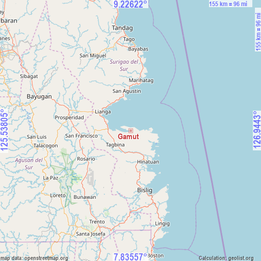
Gamut GPS coordinates[2]
8° 31' 53.508" North, 126° 14' 28.212" East
| Map corner | latitude | longitude |
|---|---|---|
| Upper-left | 9.22622°, | 125.53805° |
| Center: | 8.53153°, | 126.24117° |
| Lower-right: | 7.83557°, | 126.9443° |
| Map W x H: | 154.6×154.6 km | = 96.1×96.1mi |
| max Lat: | 20.78733° ⇑78.4% North |
| Gamut: | 8.53153° |
| min Lat: | ⇓21.6% South 4.65442° |
| min Long | Gamut | max Long |
| 117.04868° | 126.24117° | 126.58417° |
| W 99.2%⇐ | ⇒0.8% E |
Elevation
Elevation of Gamut is 11 m = 36 ft, and this is 76.9 m = 252 ft below average elevation for this country.
| Max E: |
2262 m = 7421 ft | 73.2% |
| Avg. | 87.9 m = 288 ft | |
| Gamut | 11 m = 36 ft | |
Min E: |
-2 m = -7 ft | 26.8% |
See also: Philippines elevation on elevation.city.
Geographical zone
Gamut is located in North Torrid zone (between Equator and Tropic of Cancer). Distance of Equator is 948.6 km =589.4 mi to South.| Distance of | km | miles | from Gamut |
|---|---|---|---|
| North Pole | 9058.4 | 5628.6 | to North |
| Arctic Circle | 6452.6 | 4009.5 | to North |
| Tropic Cancer | 1657.3 | 1029.8 | to North |
| Equator | 948.6 | 589.4 | to South |


Nearby cities:
15 places around Gamut: (largest is in red/bold)
• Alegria
25.4 km =15.8 mi,  263°
263°
• Amaga
18.8 km =11.7 mi,  269°
269°
• Barobo
13.2 km =8.2 mi, 271°
• Bigaan
24.2 km =15 mi,  169°
169°
• Hinatuan
20.5 km =12.7 mi,  149°
149°
• Javier
17.8 km =11.1 mi,  254°
254°
• Lapinigan
31 km =19.3 mi, 246°
• Lianga
19.7 km =12.2 mi,  305°
305°
• Los Arcos
30.3 km =18.8 mi,  291°
291°
• Loyola
24.1 km =15 mi,  155°
155°
• Rosario
30.7 km =19.1 mi,  238°
238°
• Salvacion
20.5 km =12.7 mi,  349°
349°
• Tagbina
11.7 km =7.3 mi,  220°
220°
• Tidman
28 km =17.4 mi, 157°
• Unidad
1.4 km =0.9 mi, 288°
Sources, notices
• [Note1] Compared only with cities in Philippines existing in our database
• [Src1] Map data: © OpenStreetMap contributors (CC-BY-SA)
• [Src2] Other city data from geonames.org with taken over terms of usage.
• [Src3] Geographical zone / Annual Mean Temperature by Robert A. Rohde @ Wikipedia
