Unidad geodata
Unidad (Caraga) is a populated place; located in Philippines in Asia/Manila (GMT+8) time zone. With population of 3,344 people, there are 2185 cities with bigger population in this country. Compared to other cities in Philippines, 78.3% of cities are located further ↑North; 99.1% of cities are located further ←West and 52.3% of cities have lower elevation than Unidad. Note1


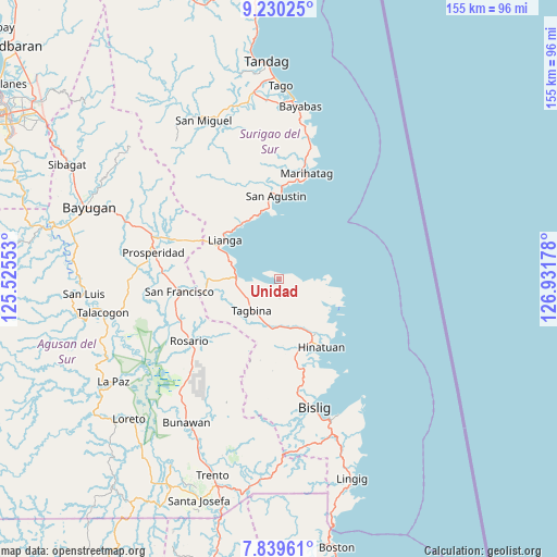
Unidad GPS coordinates[2]
8° 32' 8.016" North, 126° 13' 43.14" East
| Map corner | latitude | longitude |
|---|---|---|
| Upper-left | 9.23025°, | 125.52553° |
| Center: | 8.53556°, | 126.22865° |
| Lower-right: | 7.83961°, | 126.93178° |
| Map W x H: | 154.6×154.6 km | = 96.1×96.1mi |
| max Lat: | 20.78733° ⇑78.3% North |
| Unidad: | 8.53556° |
| min Lat: | ⇓21.7% South 4.65442° |
| min Long | Unidad | max Long |
| 117.04868° | 126.22865° | 126.58417° |
| W 99.1%⇐ | ⇒0.90000000000001% E |
Elevation
Elevation of Unidad is 25 m = 82 ft, and this is 62.9 m = 206 ft below average elevation for this country.
| Max E: |
2262 m = 7421 ft | 47.7% |
| Avg. | 87.9 m = 288 ft | |
| Unidad | 25 m = 82 ft | |
Min E: |
-2 m = -7 ft | 52.3% |
See also: Philippines elevation on elevation.city.
Geographical zone
Unidad is located in North Torrid zone (between Equator and Tropic of Cancer). Distance of Equator is 949.1 km =589.7 mi to South.| Distance of | km | miles | from Unidad |
|---|---|---|---|
| North Pole | 9058 | 5628.4 | to North |
| Arctic Circle | 6452.1 | 4009.1 | to North |
| Tropic Cancer | 1656.9 | 1029.5 | to North |
| Equator | 949.1 | 589.7 | to South |


Nearby cities:
15 places around Unidad: (largest is in red/bold)
• Alegria
24 km =14.9 mi,  262°
262°
• Amaga
17.4 km =10.8 mi,  268°
268°
• Barobo
11.8 km =7.3 mi, 269°
• Bigaan
25 km =15.5 mi,  166°
166°
• Gamut
1.4 km =0.9 mi,  108°
108°
• Hinatuan
21.6 km =13.4 mi,  147°
147°
• Javier
16.6 km =10.3 mi,  251°
251°
• Lapinigan
29.9 km =18.6 mi,  244°
244°
• Lianga
18.3 km =11.4 mi,  306°
306°
• Los Arcos
28.8 km =17.9 mi,  292°
292°
• Loyola
25.1 km =15.6 mi, 152°
• Rosario
29.8 km =18.5 mi, 236°
• Salvacion
19.8 km =12.3 mi,  353°
353°
• Tagbina
11.2 km =7 mi,  214°
214°
• Tidman
29 km =18 mi,  155°
155°
Sources, notices
• [Note1] Compared only with cities in Philippines existing in our database
• [Src1] Map data: © OpenStreetMap contributors (CC-BY-SA)
• [Src2] Other city data from geonames.org with taken over terms of usage.
• [Src3] Geographical zone / Annual Mean Temperature by Robert A. Rohde @ Wikipedia
