Lianga geodata
Lianga (Caraga) is a seat of a third-order administrative division; located in Philippines in Asia/Manila (GMT+8) time zone. With population of 13,623 people, there are 481 cities with bigger population in this country. Compared to other cities in Philippines, 77.4% of cities are located further ↑North; 98.5% of cities are located further ←West and 76.6% of cities have higher elevation than Lianga. Note1


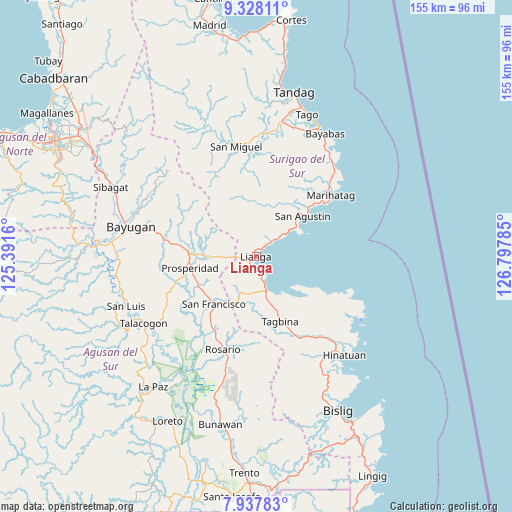
Lianga GPS coordinates[2]
8° 38' 0.996" North, 126° 5' 40.992" East
| Map corner | latitude | longitude |
|---|---|---|
| Upper-left | 9.32811°, | 125.3916° |
| Center: | 8.63361°, | 126.09472° |
| Lower-right: | 7.93783°, | 126.79785° |
| Map W x H: | 154.6×154.6 km | = 96.1×96.1mi |
| max Lat: | 20.78733° ⇑77.4% North |
| Lianga: | 8.63361° |
| min Lat: | ⇓22.6% South 4.65442° |
| min Long | Lianga | max Long |
| 117.04868° | 126.09472° | 126.58417° |
| W 98.5%⇐ | ⇒1.5% E |
Elevation
Elevation of Lianga is 10 m = 33 ft, and this is 77.9 m = 256 ft below average elevation for this country.
| Max E: |
2262 m = 7421 ft | 76.6% |
| Avg. | 87.9 m = 288 ft | |
| Lianga | 10 m = 33 ft | |
Min E: |
-2 m = -7 ft | 23.4% |
See also: Philippines elevation on elevation.city.
Geographical zone
Lianga is located in North Torrid zone (between Equator and Tropic of Cancer). Distance of Equator is 960 km =596.5 mi to South.| Distance of | km | miles | from Lianga |
|---|---|---|---|
| North Pole | 9047.1 | 5621.6 | to North |
| Arctic Circle | 6441.2 | 4002.4 | to North |
| Tropic Cancer | 1646 | 1022.8 | to North |
| Equator | 960 | 596.5 | to South |


Nearby cities:
15 places around Lianga: (largest is in red/bold)
• Alegria
16.8 km =10.4 mi,  212°
212°
• Amaga
11.7 km =7.3 mi,  193°
193°
• Bah-Bah
20 km =12.4 mi,  261°
261°
• Barobo
11.3 km =7 mi,  164°
164°
• Borbon
27.7 km =17.2 mi,  233°
233°
• Gamut
19.7 km =12.2 mi,  125°
125°
• Javier
16.1 km =10 mi,  183°
183°
• Lapinigan
26.7 km =16.6 mi, 207°
• Los Arcos
12 km =7.5 mi,  269°
269°
• Patin-ay
19.6 km =12.2 mi,  241°
241°
• Prosperidad
22.6 km =14 mi,  254°
254°
• Salvacion
15.3 km =9.5 mi,  54°
54°
• San Francisco
19.3 km =12 mi, 235°
• Tagbina
21.9 km =13.6 mi, 157°
• Unidad
18.3 km =11.4 mi, 126°
Sources, notices
• [Note1] Compared only with cities in Philippines existing in our database
• [Src1] Map data: © OpenStreetMap contributors (CC-BY-SA)
• [Src2] Other city data from geonames.org with taken over terms of usage.
• [Src3] Geographical zone / Annual Mean Temperature by Robert A. Rohde @ Wikipedia
