Pawa geodata
Pawa (Western Visayas) is a populated place; located in Philippines in Asia/Manila (GMT+8) time zone. With population of 2,138 people, there are 4016 cities with bigger population in this country. Compared to other cities in Philippines, 50.7% of cities are located further ↑North; 50.1% of cities are located further ←West and 100% of cities have higher elevation than Pawa. Note1


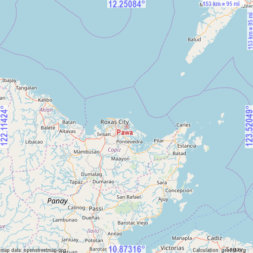
Pawa GPS coordinates[2]
11° 33' 46.26" North, 122° 49' 2.496" East
| Map corner | latitude | longitude |
|---|---|---|
| Upper-left | 12.25084°, | 122.11424° |
| Center: | 11.56285°, | 122.81736° |
| Lower-right: | 10.87316°, | 123.52049° |
| Map W x H: | 153.2×153.2 km | = 95.2×95.2mi |
| max Lat: | 20.78733° ⇑50.7% North |
| Pawa: | 11.56285° |
| min Lat: | ⇓49.3% South 4.65442° |
| min Long | Pawa | max Long |
| 117.04868° | 122.81736° | 126.58417° |
| W 50.1%⇐ | ⇒49.9% E |
Elevation
Elevation of Pawa is 0 m = 0 ft, and this is 87.9 m = 288 ft below average elevation for this country.
| Max E: |
2262 m = 7421 ft | 100% |
| Avg. | 87.9 m = 288 ft | |
| Pawa | 0 m = 0 ft | |
Min E: |
-2 m = -7 ft | 0% |
See also: Philippines elevation on elevation.city.
Geographical zone
Pawa is located in North Torrid zone (between Equator and Tropic of Cancer). Distance of Equator is 1285.7 km =798.9 mi to South.| Distance of | km | miles | from Pawa |
|---|---|---|---|
| North Pole | 8721.4 | 5419.2 | to North |
| Arctic Circle | 6115.5 | 3800 | to North |
| Tropic Cancer | 1320.3 | 820.4 | to North |
| Equator | 1285.7 | 798.9 | to South |


Nearby cities:
15 places around Pawa: (largest is in red/bold)
• Bailan
11.7 km =7.3 mi,  173°
173°
• Bolo
7 km =4.3 mi,  249°
249°
• Cogon
11.1 km =6.9 mi,  188°
188°
• Intampilan
12.1 km =7.5 mi,  221°
221°
• Lanot
8.2 km =5.1 mi,  233°
233°
• Lono
11 km =6.8 mi,  240°
240°
• Panay
2.6 km =1.6 mi,  257°
257°
• Panitan
11.8 km =7.3 mi,  204°
204°
• Pontevedra
9.2 km =5.7 mi, 169°
• Rizal
13.9 km =8.6 mi,  160°
160°
• Roxas City
7.6 km =4.7 mi,  289°
289°
• Sibaguan
11.3 km =7 mi,  267°
267°
• Tabuc Pontevedra
8.8 km =5.5 mi,  180°
180°
• Tanza
4.3 km =2.7 mi,  300°
300°
• Timpas
13.1 km =8.1 mi, 224°
Sources, notices
• [Note1] Compared only with cities in Philippines existing in our database
• [Src1] Map data: © OpenStreetMap contributors (CC-BY-SA)
• [Src2] Other city data from geonames.org with taken over terms of usage.
• [Src3] Geographical zone / Annual Mean Temperature by Robert A. Rohde @ Wikipedia
