Makilala geodata
Makilala (Soccsksargen) is a seat of a third-order administrative division; located in Philippines in Asia/Manila (GMT+8) time zone. With population of 13,829 people, there are 473 cities with bigger population in this country. Compared to other cities in Philippines, 92.2% of cities are located further ↑North; 89.2% of cities are located further ←West and 92.1% of cities have lower elevation than Makilala. Note1


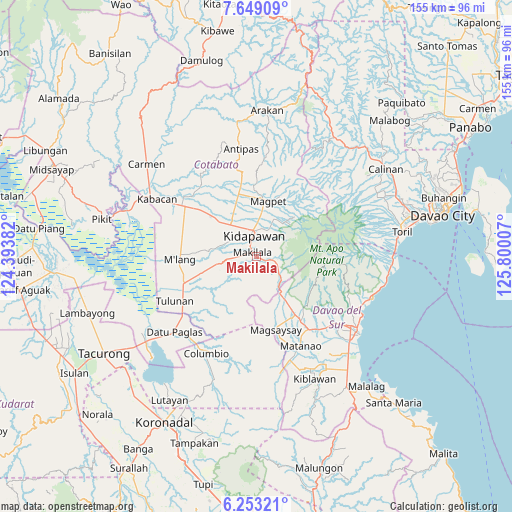
Makilala GPS coordinates[2]
6° 57' 6.012" North, 125° 5' 48.984" East
| Map corner | latitude | longitude |
|---|---|---|
| Upper-left | 7.64909°, | 124.39382° |
| Center: | 6.95167°, | 125.09694° |
| Lower-right: | 6.25321°, | 125.80007° |
| Map W x H: | 155.2×155.2 km | = 96.4×96.4mi |
| max Lat: | 20.78733° ⇑92.2% North |
| Makilala: | 6.95167° |
| min Lat: | ⇓7.8% South 4.65442° |
| min Long | Makilala | max Long |
| 117.04868° | 125.09694° | 126.58417° |
| W 89.2%⇐ | ⇒10.8% E |
Elevation
Elevation of Makilala is 289 m = 948 ft, and this is 201.1 m = 660 ft above average elevation for this country.
| Max E: |
2262 m = 7421 ft | 7.9% |
| Makilala | 289 m 948 ft | |
| Avg. | 87.9 m = 288 ft | |
Min E: |
-2 m = -7 ft | 92.1% |
See also: Philippines elevation on elevation.city.
Geographical zone
Makilala is located in North Torrid zone (between Equator and Tropic of Cancer). Distance of Equator is 773 km =480.3 mi to South.| Distance of | km | miles | from Makilala |
|---|---|---|---|
| North Pole | 9234.1 | 5737.8 | to North |
| Arctic Circle | 6628.2 | 4118.6 | to North |
| Tropic Cancer | 1833 | 1139 | to North |
| Equator | 773 | 480.3 | to South |


Nearby cities:
15 places around Makilala: (largest is in red/bold)
• Amas
17.1 km =10.6 mi,  313°
313°
• Bansalan
22.4 km =13.9 mi,  145°
145°
• Batasan
10.5 km =6.5 mi,  330°
330°
• Bulatukan
8.9 km =5.5 mi,  127°
127°
• Dolo
18.9 km =11.7 mi, 146°
• Kalaisan
8.7 km =5.4 mi,  318°
318°
• Kidapawan
6.4 km =4 mi,  352°
352°
• Kisante
7.2 km =4.5 mi,  116°
116°
• Labu-o
18.9 km =11.7 mi,  342°
342°
• Magpet
16.6 km =10.3 mi,  7°
7°
• Magsaysay
22.7 km =14.1 mi,  155°
155°
• Malamote
22 km =13.7 mi, 308°
• Malasila
3.7 km =2.3 mi,  103°
103°
• New Cebu
17.4 km =10.8 mi, 336°
• Saguing
3.8 km =2.4 mi, 326°
Sources, notices
• [Note1] Compared only with cities in Philippines existing in our database
• [Src1] Map data: © OpenStreetMap contributors (CC-BY-SA)
• [Src2] Other city data from geonames.org with taken over terms of usage.
• [Src3] Geographical zone / Annual Mean Temperature by Robert A. Rohde @ Wikipedia
