Kidapawan geodata
Kidapawan (Soccsksargen) is a seat of a third-order administrative division; located in Philippines in Asia/Manila (GMT+8) time zone. With population of 79,652 people, there are 114 cities with bigger population in this country. Compared to other cities in Philippines, 91.7% of cities are located further ↑North; 89.1% of cities are located further ←West and 91.6% of cities have lower elevation than Kidapawan. Note1
Administrative division(s):
- Level 1: Soccsksargen
- Level 2: Province of Cotabato
- Level 3: City of Kidapawan


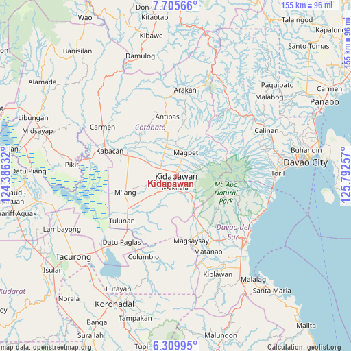
Kidapawan GPS coordinates[2]
7° 0' 29.988" North, 125° 5' 21.984" East
| Map corner | latitude | longitude |
|---|---|---|
| Upper-left | 7.70566°, | 124.38632° |
| Center: | 7.00833°, | 125.08944° |
| Lower-right: | 6.30995°, | 125.79257° |
| Map W x H: | 155.2×155.2 km | = 96.4×96.4mi |
| max Lat: | 20.78733° ⇑91.7% North |
| Kidapawan: | 7.00833° |
| min Lat: | ⇓8.3% South 4.65442° |
| min Long | Kidapawan | max Long |
| 117.04868° | 125.08944° | 126.58417° |
| W 89.1%⇐ | ⇒10.9% E |
Elevation
Elevation of Kidapawan is 275 m = 902 ft, and this is 187.1 m = 614 ft above average elevation for this country.
| Max E: |
2262 m = 7421 ft | 8.4% |
| Kidapawan | 275 m 902 ft | |
| Avg. | 87.9 m = 288 ft | |
Min E: |
-2 m = -7 ft | 91.6% |
See also: Kidapawan elevation on elevation.city.
Geographical zone
Kidapawan is located in North Torrid zone (between Equator and Tropic of Cancer). Distance of Equator is 779.3 km =484.2 mi to South.| Distance of | km | miles | from Kidapawan |
|---|---|---|---|
| North Pole | 9227.8 | 5733.9 | to North |
| Arctic Circle | 6621.9 | 4114.7 | to North |
| Tropic Cancer | 1826.7 | 1135.1 | to North |
| Equator | 779.3 | 484.2 | to South |


Nearby cities:
15 places around Kidapawan: (largest is in red/bold)
• Amas
12.8 km =8 mi,  294°
294°
• Batasan
5.2 km =3.2 mi,  302°
302°
• Bialong
22.3 km =13.9 mi,  262°
262°
• Bulatukan
14.2 km =8.8 mi,  146°
146°
• Kalaisan
4.9 km =3 mi,  272°
272°
• Kisante
11.9 km =7.4 mi,  142°
142°
• Labu-o
12.7 km =7.9 mi,  337°
337°
• Magpet
10.6 km =6.6 mi,  15°
15°
• Makilala
6.4 km =4 mi,  172°
172°
• Malamote
18 km =11.2 mi, 293°
• Malasila
8.4 km =5.2 mi, 148°
• New Cebu
11.5 km =7.1 mi,  327°
327°
• Paatan
22.1 km =13.7 mi, 304°
• President Roxas
16.7 km =10.4 mi,  347°
347°
• Saguing
3.4 km =2.1 mi,  201°
201°
Sources, notices
• [Note1] Compared only with cities in Philippines existing in our database
• [Src1] Map data: © OpenStreetMap contributors (CC-BY-SA)
• [Src2] Other city data from geonames.org with taken over terms of usage.
• [Src3] Geographical zone / Annual Mean Temperature by Robert A. Rohde @ Wikipedia
