Saguing geodata
Saguing (Soccsksargen) is a populated place; located in Philippines in Asia/Manila (GMT+8) time zone. With population of 5,073 people, there are 1269 cities with bigger population in this country. Compared to other cities in Philippines, 91.9% of cities are located further ↑North; 89.1% of cities are located further ←West and 89.5% of cities have lower elevation than Saguing. Note1


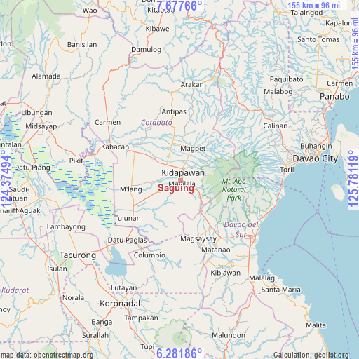
Saguing GPS coordinates[2]
6° 58' 49.008" North, 125° 4' 41.016" East
| Map corner | latitude | longitude |
|---|---|---|
| Upper-left | 7.67766°, | 124.37494° |
| Center: | 6.98028°, | 125.07806° |
| Lower-right: | 6.28186°, | 125.78119° |
| Map W x H: | 155.2×155.2 km | = 96.4×96.4mi |
| max Lat: | 20.78733° ⇑91.9% North |
| Saguing: | 6.98028° |
| min Lat: | ⇓8.1% South 4.65442° |
| min Long | Saguing | max Long |
| 117.04868° | 125.07806° | 126.58417° |
| W 89.1%⇐ | ⇒10.9% E |
Elevation
Elevation of Saguing is 219 m = 719 ft, and this is 131.1 m = 430 ft above average elevation for this country.
| Max E: |
2262 m = 7421 ft | 10.5% |
| Saguing | 219 m 719 ft | |
| Avg. | 87.9 m = 288 ft | |
Min E: |
-2 m = -7 ft | 89.5% |
See also: Philippines elevation on elevation.city.
Geographical zone
Saguing is located in North Torrid zone (between Equator and Tropic of Cancer). Distance of Equator is 776.1 km =482.2 mi to South.| Distance of | km | miles | from Saguing |
|---|---|---|---|
| North Pole | 9230.9 | 5735.8 | to North |
| Arctic Circle | 6625 | 4116.6 | to North |
| Tropic Cancer | 1829.8 | 1137 | to North |
| Equator | 776.1 | 482.2 | to South |


Nearby cities:
15 places around Saguing: (largest is in red/bold)
• Amas
13.4 km =8.3 mi,  309°
309°
• Batasan
6.7 km =4.2 mi,  332°
332°
• Bialong
20.9 km =13 mi,  270°
270°
• Bulatukan
12.6 km =7.8 mi,  133°
133°
• Dolo
22.7 km =14.1 mi,  146°
146°
• Kalaisan
4.9 km =3 mi, 312°
• Kidapawan
3.4 km =2.1 mi,  21°
21°
• Kisante
10.6 km =6.6 mi, 126°
• Labu-o
15.3 km =9.5 mi,  346°
346°
• Magpet
14 km =8.7 mi, 17°
• Makilala
3.8 km =2.4 mi, 146°
• Malamote
18.5 km =11.5 mi,  304°
304°
• Malasila
7 km =4.3 mi, 125°
• New Cebu
13.7 km =8.5 mi,  339°
339°
• President Roxas
19.5 km =12.1 mi, 352°
Sources, notices
• [Note1] Compared only with cities in Philippines existing in our database
• [Src1] Map data: © OpenStreetMap contributors (CC-BY-SA)
• [Src2] Other city data from geonames.org with taken over terms of usage.
• [Src3] Geographical zone / Annual Mean Temperature by Robert A. Rohde @ Wikipedia
