San Vicente geodata
San Vicente (Cagayan Valley) is a populated place; located in Philippines in Asia/Manila (GMT+8) time zone. With population of 3,269 people, there are 2240 cities with bigger population in this country. Compared to other cities in Philippines, 99.7% of cities are located further ↓South; 58.5% of cities are located further →East and 97.1% of cities have higher elevation than San Vicente. Note1


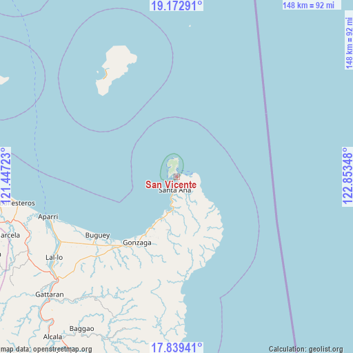
San Vicente GPS coordinates[2]
18° 30' 26.856" North, 122° 9' 1.26" East
| Map corner | latitude | longitude |
|---|---|---|
| Upper-left | 19.17291°, | 121.44723° |
| Center: | 18.50746°, | 122.15035° |
| Lower-right: | 17.83941°, | 122.85348° |
| Map W x H: | 148.3×148.3 km | = 92.1×92.1mi |
| max Lat: | 20.78733° ⇑0.3% North |
| San Vicente: | 18.50746° |
| min Lat: | ⇓99.7% South 4.65442° |
| min Long | San Vicente | max Long |
| 117.04868° | 122.15035° | 126.58417° |
| W 41.5%⇐ | ⇒58.5% E |
Elevation
Elevation of San Vicente is 4 m = 13 ft, and this is 83.9 m = 275 ft below average elevation for this country.
| Max E: |
2262 m = 7421 ft | 97.1% |
| Avg. | 87.9 m = 288 ft | |
| San Vicente | 4 m = 13 ft | |
Min E: |
-2 m = -7 ft | 2.9% |
See also: Philippines elevation on elevation.city.
Geographical zone
San Vicente is located in North Torrid zone (between Equator and Tropic of Cancer). Distance of this Northern Tropic circle is 548.1 km =340.6 mi to North.| Distance of | km | miles | from San Vicente |
|---|---|---|---|
| North Pole | 7949.2 | 4939.4 | to North |
| Arctic Circle | 5343.3 | 3320.2 | to North |
| Tropic Cancer | 548.1 | 340.6 | to North |
| Equator | 2057.8 | 1278.7 | to South |


Nearby cities:
15 places around San Vicente: (largest is in red/bold)
• Aparri
56.3 km =35 mi,  252°
252°
• Bagumbayan
62.1 km =38.6 mi,  235°
235°
• Buguey
41.4 km =25.7 mi,  233°
233°
• Cabiraoan
21.5 km =13.4 mi,  198°
198°
• Camalaniugan
56.5 km =35.1 mi, 242°
• Capissayan Sur
61.7 km =38.3 mi,  214°
214°
• Casambalangan
14.8 km =9.2 mi,  189°
189°
• Gonzaga
32.1 km =19.9 mi, 210°
• Maxingal
60.4 km =37.5 mi, 237°
• Paddaya
45.8 km =28.5 mi, 241°
• Paddaya
48 km =29.8 mi, 244°
• Pattao
45.8 km =28.5 mi, 230°
• Santa Ana
4.2 km =2.6 mi,  183°
183°
• Santa Teresita
38.3 km =23.8 mi,  220°
220°
• Tapel
27.4 km =17 mi, 207°
Sources, notices
• [Note1] Compared only with cities in Philippines existing in our database
• [Src1] Map data: © OpenStreetMap contributors (CC-BY-SA)
• [Src2] Other city data from geonames.org with taken over terms of usage.
• [Src3] Geographical zone / Annual Mean Temperature by Robert A. Rohde @ Wikipedia
