Pasacao geodata
Pasacao (Bicol) is a seat of a third-order administrative division; located in Philippines in Asia/Manila (GMT+8) time zone. With population of 10,531 people, there are 586 cities with bigger population in this country. Compared to other cities in Philippines, 62.3% of cities are located further ↓South; 54% of cities are located further ←West and 76.6% of cities have higher elevation than Pasacao. Note1


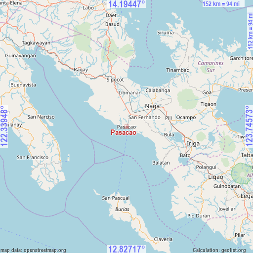
Pasacao GPS coordinates[2]
13° 30' 42.48" North, 123° 2' 33.36" East
| Map corner | latitude | longitude |
|---|---|---|
| Upper-left | 14.19447°, | 122.33948° |
| Center: | 13.5118°, | 123.0426° |
| Lower-right: | 12.82717°, | 123.74573° |
| Map W x H: | 152×152 km | = 94.4×94.4mi |
| max Lat: | 20.78733° ⇑37.7% North |
| Pasacao: | 13.5118° |
| min Lat: | ⇓62.3% South 4.65442° |
| min Long | Pasacao | max Long |
| 117.04868° | 123.0426° | 126.58417° |
| W 54%⇐ | ⇒46% E |
Elevation
Elevation of Pasacao is 10 m = 33 ft, and this is 77.9 m = 256 ft below average elevation for this country.
| Max E: |
2262 m = 7421 ft | 76.6% |
| Avg. | 87.9 m = 288 ft | |
| Pasacao | 10 m = 33 ft | |
Min E: |
-2 m = -7 ft | 23.4% |
See also: Philippines elevation on elevation.city.
Geographical zone
Pasacao is located in North Torrid zone (between Equator and Tropic of Cancer). Distance of this Northern Tropic circle is 1103.5 km =685.7 mi to North.| Distance of | km | miles | from Pasacao |
|---|---|---|---|
| North Pole | 8504.7 | 5284.6 | to North |
| Arctic Circle | 5898.8 | 3665.3 | to North |
| Tropic Cancer | 1103.5 | 685.7 | to North |
| Equator | 1502.4 | 933.5 | to South |


Nearby cities:
15 places around Pasacao: (largest is in red/bold)
• Antipolo
13.1 km =8.1 mi,  81°
81°
• Bahay
3.6 km =2.2 mi,  356°
356°
• Balogo
2.6 km =1.6 mi,  116°
116°
• Beberon
11.2 km =7 mi,  71°
71°
• Caranan
3 km =1.9 mi,  280°
280°
• Dalupaon
11.4 km =7.1 mi,  292°
292°
• Lupi
11.9 km =7.4 mi, 78°
• Odicon
2.7 km =1.7 mi,  40°
40°
• Pamplona
9.8 km =6.1 mi,  25°
25°
• Quitang
4.5 km =2.8 mi,  14°
14°
• San Fernando
12.6 km =7.8 mi,  61°
61°
• San Gabriel
8.7 km =5.4 mi,  45°
45°
• San Ramon
11.8 km =7.3 mi, 357°
• San Vicente
7 km =4.3 mi, 9°
• Tambo
4 km =2.5 mi,  349°
349°
Sources, notices
• [Note1] Compared only with cities in Philippines existing in our database
• [Src1] Map data: © OpenStreetMap contributors (CC-BY-SA)
• [Src2] Other city data from geonames.org with taken over terms of usage.
• [Src3] Geographical zone / Annual Mean Temperature by Robert A. Rohde @ Wikipedia
