San Ramon geodata
San Ramon (Bicol) is a populated place; located in Philippines in Asia/Manila (GMT+8) time zone. With population of 2,149 people, there are 3990 cities with bigger population in this country. Compared to other cities in Philippines, 63.6% of cities are located further ↓South; 53.9% of cities are located further ←West and 61.5% of cities have lower elevation than San Ramon. Note1


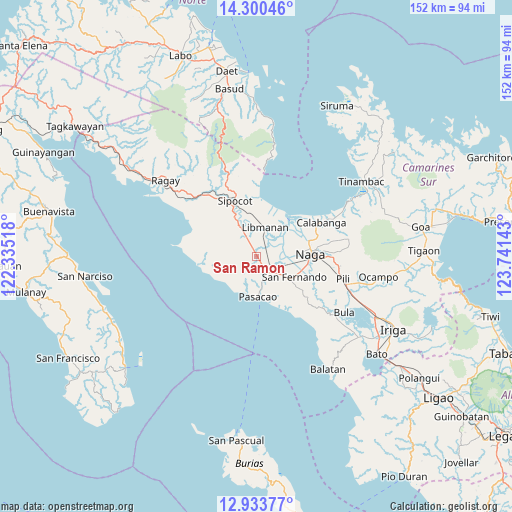
San Ramon GPS coordinates[2]
13° 37' 5.16" North, 123° 2' 17.88" East
| Map corner | latitude | longitude |
|---|---|---|
| Upper-left | 14.30046°, | 122.33518° |
| Center: | 13.6181°, | 123.0383° |
| Lower-right: | 12.93377°, | 123.74143° |
| Map W x H: | 152×152 km | = 94.4×94.4mi |
| max Lat: | 20.78733° ⇑36.4% North |
| San Ramon: | 13.6181° |
| min Lat: | ⇓63.6% South 4.65442° |
| min Long | San Ramon | max Long |
| 117.04868° | 123.0383° | 126.58417° |
| W 53.9%⇐ | ⇒46.1% E |
Elevation
Elevation of San Ramon is 36 m = 118 ft, and this is 51.9 m = 170 ft below average elevation for this country.
| Max E: |
2262 m = 7421 ft | 38.5% |
| Avg. | 87.9 m = 288 ft | |
| San Ramon | 36 m = 118 ft | |
Min E: |
-2 m = -7 ft | 61.5% |
See also: Philippines elevation on elevation.city.
Geographical zone
San Ramon is located in North Torrid zone (between Equator and Tropic of Cancer). Distance of this Northern Tropic circle is 1091.7 km =678.4 mi to North.| Distance of | km | miles | from San Ramon |
|---|---|---|---|
| North Pole | 8492.9 | 5277.2 | to North |
| Arctic Circle | 5887 | 3658 | to North |
| Tropic Cancer | 1091.7 | 678.4 | to North |
| Equator | 1514.2 | 940.9 | to South |


Nearby cities:
15 places around San Ramon: (largest is in red/bold)
• Bahay
8.3 km =5.2 mi,  178°
178°
• Balogo
13.2 km =8.2 mi,  167°
167°
• Caranan
11.5 km =7.1 mi,  192°
192°
• Dalupaon
12.4 km =7.7 mi,  233°
233°
• Gainza
11.2 km =7 mi,  90°
90°
• Libmanan
8.6 km =5.3 mi,  15°
15°
• Mambulo
11 km =6.8 mi,  6°
6°
• Odicon
10 km =6.2 mi, 167°
• Pamplona
5.5 km =3.4 mi,  122°
122°
• Pasacao
11.8 km =7.3 mi, 177°
• Quitang
7.6 km =4.7 mi, 168°
• San Fernando
13 km =8.1 mi, 116°
• San Gabriel
8.8 km =5.5 mi,  130°
130°
• San Vicente
5.2 km =3.2 mi,  161°
161°
• Tambo
7.9 km =4.9 mi, 181°
Sources, notices
• [Note1] Compared only with cities in Philippines existing in our database
• [Src1] Map data: © OpenStreetMap contributors (CC-BY-SA)
• [Src2] Other city data from geonames.org with taken over terms of usage.
• [Src3] Geographical zone / Annual Mean Temperature by Robert A. Rohde @ Wikipedia
