Balogo geodata
Balogo (Bicol) is a populated place; located in Philippines in Asia/Manila (GMT+8) time zone. With population of 3,190 people, there are 2320 cities with bigger population in this country. Compared to other cities in Philippines, 62.1% of cities are located further ↓South; 54.4% of cities are located further ←West and 89.7% of cities have higher elevation than Balogo. Note1


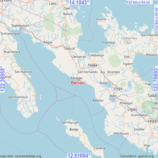
Balogo GPS coordinates[2]
13° 30' 5.76" North, 123° 3' 49.68" East
| Map corner | latitude | longitude |
|---|---|---|
| Upper-left | 14.1843°, | 122.36068° |
| Center: | 13.5016°, | 123.0638° |
| Lower-right: | 12.81694°, | 123.76693° |
| Map W x H: | 152×152 km | = 94.4×94.4mi |
| max Lat: | 20.78733° ⇑37.9% North |
| Balogo: | 13.5016° |
| min Lat: | ⇓62.1% South 4.65442° |
| min Long | Balogo | max Long |
| 117.04868° | 123.0638° | 126.58417° |
| W 54.4%⇐ | ⇒45.6% E |
Elevation
Elevation of Balogo is 7 m = 23 ft, and this is 80.9 m = 265 ft below average elevation for this country.
| Max E: |
2262 m = 7421 ft | 89.7% |
| Avg. | 87.9 m = 288 ft | |
| Balogo | 7 m = 23 ft | |
Min E: |
-2 m = -7 ft | 10.3% |
See also: Philippines elevation on elevation.city.
Geographical zone
Balogo is located in North Torrid zone (between Equator and Tropic of Cancer). Distance of this Northern Tropic circle is 1104.7 km =686.4 mi to North.| Distance of | km | miles | from Balogo |
|---|---|---|---|
| North Pole | 8505.8 | 5285.3 | to North |
| Arctic Circle | 5899.9 | 3666 | to North |
| Tropic Cancer | 1104.7 | 686.4 | to North |
| Equator | 1501.2 | 932.8 | to South |


Nearby cities:
15 places around Balogo: (largest is in red/bold)
• Antipolo
11.1 km =6.9 mi,  74°
74°
• Bahay
5.3 km =3.3 mi,  331°
331°
• Beberon
9.6 km =6 mi,  60°
60°
• Caranan
5.5 km =3.4 mi,  287°
287°
• Hobo
12.5 km =7.8 mi,  85°
85°
• Lupi
10 km =6.2 mi, 69°
• Odicon
3.2 km =2 mi,  350°
350°
• Pamplona
10.2 km =6.3 mi,  10°
10°
• Pasacao
2.6 km =1.6 mi,  296°
296°
• Quitang
5.7 km =3.5 mi, 347°
• San Fernando
11.3 km =7 mi,  51°
51°
• San Gabriel
8.2 km =5.1 mi,  28°
28°
• San Ramon
13.2 km =8.2 mi, 347°
• San Vicente
8.1 km =5 mi, 351°
• Tambo
5.9 km =3.7 mi, 328°
Sources, notices
• [Note1] Compared only with cities in Philippines existing in our database
• [Src1] Map data: © OpenStreetMap contributors (CC-BY-SA)
• [Src2] Other city data from geonames.org with taken over terms of usage.
• [Src3] Geographical zone / Annual Mean Temperature by Robert A. Rohde @ Wikipedia
