Odicon geodata
Odicon (Bicol) is a populated place; located in Philippines in Asia/Manila (GMT+8) time zone. With population of 2,439 people, there are 3401 cities with bigger population in this country. Compared to other cities in Philippines, 62.5% of cities are located further ↓South; 54.3% of cities are located further ←West and 54.5% of cities have higher elevation than Odicon. Note1


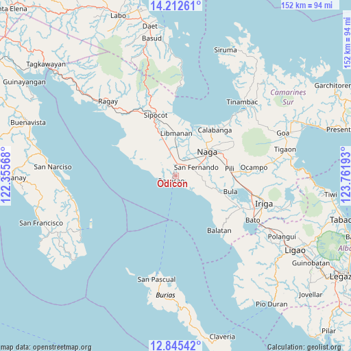
Odicon GPS coordinates[2]
13° 31' 48" North, 123° 3' 31.68" East
| Map corner | latitude | longitude |
|---|---|---|
| Upper-left | 14.21261°, | 122.35568° |
| Center: | 13.53°, | 123.0588° |
| Lower-right: | 12.84542°, | 123.76193° |
| Map W x H: | 152×152 km | = 94.4×94.4mi |
| max Lat: | 20.78733° ⇑37.5% North |
| Odicon: | 13.53° |
| min Lat: | ⇓62.5% South 4.65442° |
| min Long | Odicon | max Long |
| 117.04868° | 123.0588° | 126.58417° |
| W 54.3%⇐ | ⇒45.7% E |
Elevation
Elevation of Odicon is 20 m = 66 ft, and this is 67.9 m = 223 ft below average elevation for this country.
| Max E: |
2262 m = 7421 ft | 54.5% |
| Avg. | 87.9 m = 288 ft | |
| Odicon | 20 m = 66 ft | |
Min E: |
-2 m = -7 ft | 45.5% |
See also: Philippines elevation on elevation.city.
Geographical zone
Odicon is located in North Torrid zone (between Equator and Tropic of Cancer). Distance of this Northern Tropic circle is 1101.5 km =684.4 mi to North.| Distance of | km | miles | from Odicon |
|---|---|---|---|
| North Pole | 8502.7 | 5283.3 | to North |
| Arctic Circle | 5896.8 | 3664.1 | to North |
| Tropic Cancer | 1101.5 | 684.4 | to North |
| Equator | 1504.4 | 934.8 | to South |


Nearby cities:
15 places around Odicon: (largest is in red/bold)
• Antipolo
11.2 km =7 mi,  90°
90°
• Bahay
2.5 km =1.6 mi,  307°
307°
• Balogo
3.2 km =2 mi,  170°
170°
• Beberon
9 km =5.6 mi,  79°
79°
• Caranan
4.9 km =3 mi,  252°
252°
• Dalupaon
12.5 km =7.8 mi,  281°
281°
• Lupi
9.9 km =6.2 mi, 87°
• Pamplona
7.3 km =4.5 mi,  19°
19°
• Pasacao
2.7 km =1.7 mi,  220°
220°
• Quitang
2.5 km =1.6 mi,  344°
344°
• San Fernando
10.2 km =6.3 mi,  67°
67°
• San Gabriel
6 km =3.7 mi,  47°
47°
• San Ramon
10 km =6.2 mi,  347°
347°
• San Vicente
4.9 km =3 mi, 353°
• Tambo
3.1 km =1.9 mi, 306°
Sources, notices
• [Note1] Compared only with cities in Philippines existing in our database
• [Src1] Map data: © OpenStreetMap contributors (CC-BY-SA)
• [Src2] Other city data from geonames.org with taken over terms of usage.
• [Src3] Geographical zone / Annual Mean Temperature by Robert A. Rohde @ Wikipedia
