New Pandanon geodata
New Pandanon (Western Visayas) is a populated place; located in Philippines in Asia/Manila (GMT+8) time zone. With population of 2,201 people, there are 3887 cities with bigger population in this country. Compared to other cities in Philippines, 62.5% of cities are located further ↑North; 55.8% of cities are located further ←West and 88.4% of cities have lower elevation than New Pandanon. Note1
Administrative division(s):
- Level 1: Western Visayas
- Level 2: Province of Negros Occidental
- Level 3: Murcia


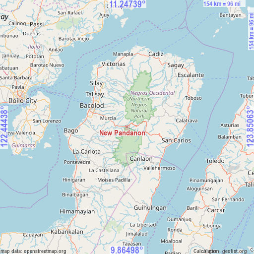
New Pandanon GPS coordinates[2]
10° 33' 25.056" North, 123° 8' 51" East
| Map corner | latitude | longitude |
|---|---|---|
| Upper-left | 11.24739°, | 122.44438° |
| Center: | 10.55696°, | 123.1475° |
| Lower-right: | 9.86498°, | 123.85063° |
| Map W x H: | 153.7×153.7 km | = 95.5×95.5mi |
| max Lat: | 20.78733° ⇑62.5% North |
| New Pandanon: | 10.55696° |
| min Lat: | ⇓37.5% South 4.65442° |
| min Long | New Pandanon | max Long |
| 117.04868° | 123.1475° | 126.58417° |
| W 55.8%⇐ | ⇒44.2% E |
Elevation
Elevation of New Pandanon is 190 m = 623 ft, and this is 102.1 m = 335 ft above average elevation for this country.
| Max E: |
2262 m = 7421 ft | 11.6% |
| New Pandanon | 190 m 623 ft | |
| Avg. | 87.9 m = 288 ft | |
Min E: |
-2 m = -7 ft | 88.4% |
See also: Philippines elevation on elevation.city.
Geographical zone
New Pandanon is located in North Torrid zone (between Equator and Tropic of Cancer). Distance of Equator is 1173.8 km =729.4 mi to South.| Distance of | km | miles | from New Pandanon |
|---|---|---|---|
| North Pole | 8833.2 | 5488.7 | to North |
| Arctic Circle | 6227.4 | 3869.5 | to North |
| Tropic Cancer | 1432.1 | 889.9 | to North |
| Equator | 1173.8 | 729.4 | to South |


Nearby cities:
15 places around New Pandanon: (largest is in red/bold)
• Alegria
11.9 km =7.4 mi,  324°
324°
• Buenavista
8.3 km =5.2 mi, 320°
• Cansilayan
14.1 km =8.8 mi,  271°
271°
• Codcod
15.3 km =9.5 mi,  133°
133°
• Concepcion
17.8 km =11.1 mi,  327°
327°
• Hacienda Santa Rosa
5.3 km =3.3 mi,  288°
288°
• Igmaya-an
8 km =5 mi,  95°
95°
• Kumalisquis
8.2 km =5.1 mi, 132°
• Maao
18.7 km =11.6 mi,  246°
246°
• Minuyan
6.7 km =4.2 mi,  224°
224°
• Murcia
12.7 km =7.9 mi, 294°
• Prosperidad
18.2 km =11.3 mi, 104°
• Quezon
18.2 km =11.3 mi,  137°
137°
• San Miguel
7.3 km =4.5 mi, 253°
• Santa Cruz
11.1 km =6.9 mi, 320°
Sources, notices
• [Note1] Compared only with cities in Philippines existing in our database
• [Src1] Map data: © OpenStreetMap contributors (CC-BY-SA)
• [Src2] Other city data from geonames.org with taken over terms of usage.
• [Src3] Geographical zone / Annual Mean Temperature by Robert A. Rohde @ Wikipedia
