Murcia geodata
Murcia (Western Visayas) is a seat of a third-order administrative division; located in Philippines in Asia/Manila (GMT+8) time zone. With population of 17,448 people, there are 400 cities with bigger population in this country. Compared to other cities in Philippines, 61.9% of cities are located further ↑North; 54% of cities are located further ←West and 86.1% of cities have lower elevation than Murcia. Note1
Administrative division(s):
- Level 1: Western Visayas
- Level 2: Province of Negros Occidental
- Level 3: Murcia


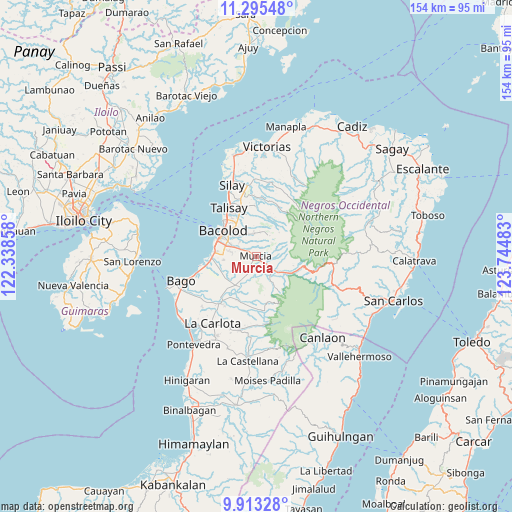
Murcia GPS coordinates[2]
10° 36' 18.576" North, 123° 2' 30.12" East
| Map corner | latitude | longitude |
|---|---|---|
| Upper-left | 11.29548°, | 122.33858° |
| Center: | 10.60516°, | 123.0417° |
| Lower-right: | 9.91328°, | 123.74483° |
| Map W x H: | 153.7×153.7 km | = 95.5×95.5mi |
| max Lat: | 20.78733° ⇑61.9% North |
| Murcia: | 10.60516° |
| min Lat: | ⇓38.1% South 4.65442° |
| min Long | Murcia | max Long |
| 117.04868° | 123.0417° | 126.58417° |
| W 54%⇐ | ⇒46% E |
Elevation
Elevation of Murcia is 152 m = 499 ft, and this is 64.1 m = 210 ft above average elevation for this country.
| Max E: |
2262 m = 7421 ft | 13.9% |
| Murcia | 152 m 499 ft | |
| Avg. | 87.9 m = 288 ft | |
Min E: |
-2 m = -7 ft | 86.1% |
See also: Philippines elevation on elevation.city.
Geographical zone
Murcia is located in North Torrid zone (between Equator and Tropic of Cancer). Distance of Equator is 1179.2 km =732.7 mi to South.| Distance of | km | miles | from Murcia |
|---|---|---|---|
| North Pole | 8827.9 | 5485.4 | to North |
| Arctic Circle | 6222 | 3866.2 | to North |
| Tropic Cancer | 1426.7 | 886.5 | to North |
| Equator | 1179.2 | 732.7 | to South |


Nearby cities:
15 places around Murcia: (largest is in red/bold)
• Alegria
6.3 km =3.9 mi,  47°
47°
• Atipuluhan
13.4 km =8.3 mi,  220°
220°
• Bacolod City
12.1 km =7.5 mi,  304°
304°
• Buenavista
6.4 km =4 mi,  80°
80°
• Cansilayan
5.7 km =3.5 mi,  206°
206°
• Concepcion
9.9 km =6.2 mi,  12°
12°
• Dulao
13.3 km =8.3 mi,  238°
238°
• Hacienda Santa Rosa
7.5 km =4.7 mi,  119°
119°
• Mansilingan
7.4 km =4.6 mi,  292°
292°
• Minuyan
12.3 km =7.6 mi,  145°
145°
• New Pandanon
12.7 km =7.9 mi,  114°
114°
• San Fernando
11.9 km =7.4 mi, 14°
• San Miguel
8.7 km =5.4 mi, 148°
• Santa Cruz
5.4 km =3.4 mi, 54°
• Sumag
13.4 km =8.3 mi,  268°
268°
Sources, notices
• [Note1] Compared only with cities in Philippines existing in our database
• [Src1] Map data: © OpenStreetMap contributors (CC-BY-SA)
• [Src2] Other city data from geonames.org with taken over terms of usage.
• [Src3] Geographical zone / Annual Mean Temperature by Robert A. Rohde @ Wikipedia
