Santa Cruz geodata
Santa Cruz (Western Visayas) is a populated place; located in Philippines in Asia/Manila (GMT+8) time zone. With population of 2,919 people, there are 2623 cities with bigger population in this country. Compared to other cities in Philippines, 61.7% of cities are located further ↑North; 54.7% of cities are located further ←West and 90.9% of cities have lower elevation than Santa Cruz. Note1
Administrative division(s):
- Level 1: Western Visayas
- Level 2: Province of Negros Occidental
- Level 3: Murcia


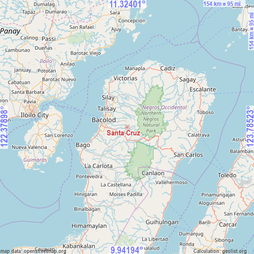
Santa Cruz GPS coordinates[2]
10° 38' 1.536" North, 123° 4' 55.56" East
| Map corner | latitude | longitude |
|---|---|---|
| Upper-left | 11.32401°, | 122.37898° |
| Center: | 10.63376°, | 123.0821° |
| Lower-right: | 9.94194°, | 123.78523° |
| Map W x H: | 153.7×153.7 km | = 95.5×95.5mi |
| max Lat: | 20.78733° ⇑61.7% North |
| Santa Cruz: | 10.63376° |
| min Lat: | ⇓38.3% South 4.65442° |
| min Long | Santa Cruz | max Long |
| 117.04868° | 123.0821° | 126.58417° |
| W 54.7%⇐ | ⇒45.3% E |
Elevation
Elevation of Santa Cruz is 252 m = 827 ft, and this is 164.1 m = 538 ft above average elevation for this country.
| Max E: |
2262 m = 7421 ft | 9.1% |
| Santa Cruz | 252 m 827 ft | |
| Avg. | 87.9 m = 288 ft | |
Min E: |
-2 m = -7 ft | 90.9% |
See also: Philippines elevation on elevation.city.
Geographical zone
Santa Cruz is located in North Torrid zone (between Equator and Tropic of Cancer). Distance of Equator is 1182.4 km =734.7 mi to South.| Distance of | km | miles | from Santa Cruz |
|---|---|---|---|
| North Pole | 8824.7 | 5483.4 | to North |
| Arctic Circle | 6218.8 | 3864.2 | to North |
| Tropic Cancer | 1423.6 | 884.6 | to North |
| Equator | 1182.4 | 734.7 | to South |


Nearby cities:
15 places around Santa Cruz: (largest is in red/bold)
• Alegria
1.1 km =0.7 mi,  8°
8°
• Bacolod City
14.9 km =9.3 mi,  284°
284°
• Buenavista
2.8 km =1.7 mi,  138°
138°
• Cansilayan
10.8 km =6.7 mi,  220°
220°
• Capitan Ramon
14.5 km =9 mi, 14°
• Concepcion
6.9 km =4.3 mi,  340°
340°
• Dos Hermanas
13 km =8.1 mi, 338°
• Hacienda Santa Rosa
7.1 km =4.4 mi,  163°
163°
• Mansilingan
11.3 km =7 mi,  268°
268°
• Minuyan
13.6 km =8.5 mi,  169°
169°
• Murcia
5.4 km =3.4 mi,  234°
234°
• New Pandanon
11.1 km =6.9 mi, 140°
• San Fernando
8.5 km =5.3 mi,  350°
350°
• San Miguel
10.6 km =6.6 mi,  179°
179°
• Talisay
17.1 km =10.6 mi,  312°
312°
Sources, notices
• [Note1] Compared only with cities in Philippines existing in our database
• [Src1] Map data: © OpenStreetMap contributors (CC-BY-SA)
• [Src2] Other city data from geonames.org with taken over terms of usage.
• [Src3] Geographical zone / Annual Mean Temperature by Robert A. Rohde @ Wikipedia
