La Paz geodata
La Paz (Central Luzon) is a seat of a third-order administrative division; located in Philippines in Asia/Manila (GMT+8) time zone. With population of 25,801 people, there are 315 cities with bigger population in this country. Compared to other cities in Philippines, 81.1% of cities are located further ↓South; 84.2% of cities are located further →East and 51.8% of cities have higher elevation than La Paz. Note1


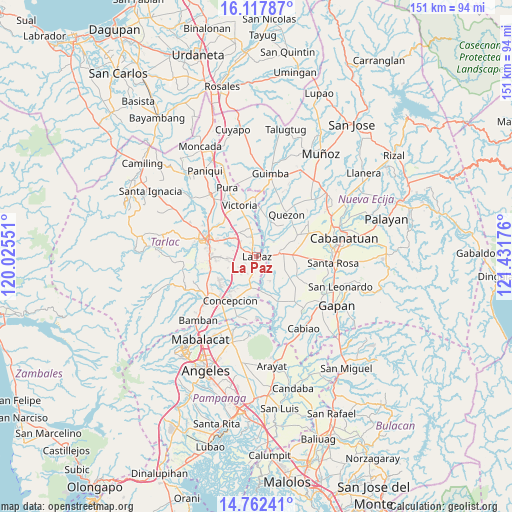
La Paz GPS coordinates[2]
15° 26' 28.5" North, 120° 43' 43.068" East
| Map corner | latitude | longitude |
|---|---|---|
| Upper-left | 16.11787°, | 120.02551° |
| Center: | 15.44125°, | 120.72863° |
| Lower-right: | 14.76241°, | 121.43176° |
| Map W x H: | 150.7×150.7 km | = 93.6×93.6mi |
| max Lat: | 20.78733° ⇑18.9% North |
| La Paz: | 15.44125° |
| min Lat: | ⇓81.1% South 4.65442° |
| min Long | La Paz | max Long |
| 117.04868° | 120.72863° | 126.58417° |
| W 15.8%⇐ | ⇒84.2% E |
Elevation
Elevation of La Paz is 22 m = 72 ft, and this is 65.9 m = 216 ft below average elevation for this country.
| Max E: |
2262 m = 7421 ft | 51.8% |
| Avg. | 87.9 m = 288 ft | |
| La Paz | 22 m = 72 ft | |
Min E: |
-2 m = -7 ft | 48.2% |
See also: Philippines elevation on elevation.city.
Geographical zone
La Paz is located in North Torrid zone (between Equator and Tropic of Cancer). Distance of this Northern Tropic circle is 889 km =552.4 mi to North.| Distance of | km | miles | from La Paz |
|---|---|---|---|
| North Pole | 8290.2 | 5151.3 | to North |
| Arctic Circle | 5684.3 | 3532.1 | to North |
| Tropic Cancer | 889 | 552.4 | to North |
| Equator | 1716.9 | 1066.8 | to South |


Nearby cities:
15 places around La Paz: (largest is in red/bold)
• Amucao
5.2 km =3.2 mi,  299°
299°
• Balingcanaway
6.5 km =4 mi,  314°
314°
• Bundoc
5.1 km =3.2 mi,  346°
346°
• Cama Juan
6.9 km =4.3 mi,  141°
141°
• Comillas
5.6 km =3.5 mi,  212°
212°
• Concepcion
7.7 km =4.8 mi,  87°
87°
• Dumarais
4 km =2.5 mi,  259°
259°
• Lomboy
5.8 km =3.6 mi, 347°
• Macarse
5.3 km =3.3 mi,  110°
110°
• Mapalacsiao
8.3 km =5.2 mi, 259°
• Motrico
6.4 km =4 mi,  241°
241°
• Panabingan
8.1 km =5 mi,  151°
151°
• Pando
7.1 km =4.4 mi,  221°
221°
• San Isidro
0.3 km =0.2 mi,  293°
293°
• Santa Lucia
6.7 km =4.2 mi,  47°
47°
Sources, notices
• [Note1] Compared only with cities in Philippines existing in our database
• [Src1] Map data: © OpenStreetMap contributors (CC-BY-SA)
• [Src2] Other city data from geonames.org with taken over terms of usage.
• [Src3] Geographical zone / Annual Mean Temperature by Robert A. Rohde @ Wikipedia
