Marawa geodata
Marawa (Central Luzon) is a populated place; located in Philippines in Asia/Manila (GMT+8) time zone. With population of 3,812 people, there are 1833 cities with bigger population in this country. Compared to other cities in Philippines, 80.9% of cities are located further ↓South; 81.3% of cities are located further →East and 51.1% of cities have lower elevation than Marawa. Note1


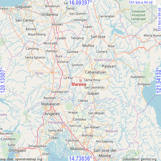
Marawa GPS coordinates[2]
15° 25' 2.172" North, 120° 50' 17.484" East
| Map corner | latitude | longitude |
|---|---|---|
| Upper-left | 16.09397°, | 120.13507° |
| Center: | 15.41727°, | 120.83819° |
| Lower-right: | 14.73836°, | 121.54132° |
| Map W x H: | 150.7×150.7 km | = 93.6×93.6mi |
| max Lat: | 20.78733° ⇑19.1% North |
| Marawa: | 15.41727° |
| min Lat: | ⇓80.9% South 4.65442° |
| min Long | Marawa | max Long |
| 117.04868° | 120.83819° | 126.58417° |
| W 18.7%⇐ | ⇒81.3% E |
Elevation
Elevation of Marawa is 24 m = 79 ft, and this is 63.9 m = 210 ft below average elevation for this country.
| Max E: |
2262 m = 7421 ft | 48.9% |
| Avg. | 87.9 m = 288 ft | |
| Marawa | 24 m = 79 ft | |
Min E: |
-2 m = -7 ft | 51.1% |
See also: Philippines elevation on elevation.city.
Geographical zone
Marawa is located in North Torrid zone (between Equator and Tropic of Cancer). Distance of this Northern Tropic circle is 891.7 km =554.1 mi to North.| Distance of | km | miles | from Marawa |
|---|---|---|---|
| North Pole | 8292.8 | 5152.9 | to North |
| Arctic Circle | 5686.9 | 3533.7 | to North |
| Tropic Cancer | 891.7 | 554.1 | to North |
| Equator | 1714.2 | 1065.2 | to South |


Nearby cities:
15 places around Marawa: (largest is in red/bold)
• Aliaga
9.2 km =5.7 mi,  3°
3°
• Batitang
4.2 km =2.6 mi,  243°
243°
• Cama Juan
8 km =5 mi,  249°
249°
• Carmen
3.5 km =2.2 mi,  339°
339°
• Concepcion
5 km =3.1 mi,  306°
306°
• Lambakin
5.6 km =3.5 mi,  154°
154°
• Lawang Kupang
8 km =5 mi,  164°
164°
• Macarse
6.9 km =4.3 mi,  277°
277°
• Panabingan
9 km =5.6 mi, 240°
• Putlod
6.1 km =3.8 mi, 148°
• Rajal Norte
4 km =2.5 mi,  40°
40°
• San Francisco
6.9 km =4.3 mi,  178°
178°
• Santa Barbara
5.8 km =3.6 mi,  231°
231°
• Santa Lucia
9.9 km =6.2 mi,  316°
316°
• Santo Rosario
5.8 km =3.6 mi,  71°
71°
Sources, notices
• [Note1] Compared only with cities in Philippines existing in our database
• [Src1] Map data: © OpenStreetMap contributors (CC-BY-SA)
• [Src2] Other city data from geonames.org with taken over terms of usage.
• [Src3] Geographical zone / Annual Mean Temperature by Robert A. Rohde @ Wikipedia
