Batitang geodata
Batitang (Central Luzon) is a populated place; located in Philippines in Asia/Manila (GMT+8) time zone. With population of 3,306 people, there are 2213 cities with bigger population in this country. Compared to other cities in Philippines, 80.8% of cities are located further ↓South; 82.1% of cities are located further →East and 50.3% of cities have higher elevation than Batitang. Note1
Administrative division(s):
- Level 1: Central Luzon
- Level 2: Province of Nueva Ecija
- Level 3: Zaragoza


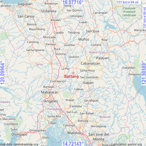
Batitang GPS coordinates[2]
15° 24' 1.44" North, 120° 48' 9.936" East
| Map corner | latitude | longitude |
|---|---|---|
| Upper-left | 16.07716°, | 120.09964° |
| Center: | 15.4004°, | 120.80276° |
| Lower-right: | 14.72143°, | 121.50589° |
| Map W x H: | 150.7×150.7 km | = 93.6×93.6mi |
| max Lat: | 20.78733° ⇑19.2% North |
| Batitang: | 15.4004° |
| min Lat: | ⇓80.8% South 4.65442° |
| min Long | Batitang | max Long |
| 117.04868° | 120.80276° | 126.58417° |
| W 17.9%⇐ | ⇒82.1% E |
Elevation
Elevation of Batitang is 23 m = 75 ft, and this is 64.9 m = 213 ft below average elevation for this country.
| Max E: |
2262 m = 7421 ft | 50.3% |
| Avg. | 87.9 m = 288 ft | |
| Batitang | 23 m = 75 ft | |
Min E: |
-2 m = -7 ft | 49.7% |
See also: Philippines elevation on elevation.city.
Geographical zone
Batitang is located in North Torrid zone (between Equator and Tropic of Cancer). Distance of this Northern Tropic circle is 893.6 km =555.3 mi to North.| Distance of | km | miles | from Batitang |
|---|---|---|---|
| North Pole | 8294.7 | 5154.1 | to North |
| Arctic Circle | 5688.8 | 3534.9 | to North |
| Tropic Cancer | 893.6 | 555.3 | to North |
| Equator | 1712.4 | 1064 | to South |


Nearby cities:
15 places around Batitang: (largest is in red/bold)
• Cama Juan
3.8 km =2.4 mi,  256°
256°
• Carmen
5.8 km =3.6 mi,  26°
26°
• Concepcion
4.9 km =3 mi,  357°
357°
• La Paz
9.2 km =5.7 mi,  299°
299°
• Lambakin
7 km =4.3 mi,  117°
117°
• Lawang Kupang
8.3 km =5.2 mi,  134°
134°
• Macarse
4.1 km =2.5 mi,  312°
312°
• Marawa
4.2 km =2.6 mi,  63°
63°
• Panabingan
4.8 km =3 mi,  237°
237°
• Putlod
7.7 km =4.8 mi, 115°
• Rajal Norte
8.1 km =5 mi,  52°
52°
• San Francisco
6.4 km =4 mi,  141°
141°
• San Isidro
9.5 km =5.9 mi, 299°
• Santa Barbara
1.9 km =1.2 mi,  202°
202°
• Santa Lucia
9.5 km =5.9 mi,  341°
341°
Sources, notices
• [Note1] Compared only with cities in Philippines existing in our database
• [Src1] Map data: © OpenStreetMap contributors (CC-BY-SA)
• [Src2] Other city data from geonames.org with taken over terms of usage.
• [Src3] Geographical zone / Annual Mean Temperature by Robert A. Rohde @ Wikipedia
