Curry geodata
Curry (Bicol) is a populated place; located in Philippines in Asia/Manila (GMT+8) time zone. With population of 2,358 people, there are 3542 cities with bigger population in this country. Compared to other cities in Philippines, 63.2% of cities are located further ↓South; 58.3% of cities are located further ←West and 78.7% of cities have lower elevation than Curry. Note1


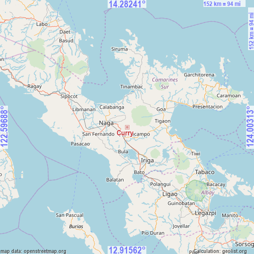
Curry GPS coordinates[2]
13° 36' 0" North, 123° 18' 0" East
| Map corner | latitude | longitude |
|---|---|---|
| Upper-left | 14.28241°, | 122.59688° |
| Center: | 13.6°, | 123.3° |
| Lower-right: | 12.91562°, | 124.00313° |
| Map W x H: | 152×152 km | = 94.4×94.4mi |
| max Lat: | 20.78733° ⇑36.8% North |
| Curry: | 13.6° |
| min Lat: | ⇓63.2% South 4.65442° |
| min Long | Curry | max Long |
| 117.04868° | 123.3° | 126.58417° |
| W 58.3%⇐ | ⇒41.7% E |
Elevation
Elevation of Curry is 84 m = 276 ft, and this is 3.9 m = 13 ft below average elevation for this country.
| Max E: |
2262 m = 7421 ft | 21.3% |
| Avg. | 87.9 m = 288 ft | |
| Curry | 84 m = 276 ft | |
Min E: |
-2 m = -7 ft | 78.7% |
See also: Philippines elevation on elevation.city.
Geographical zone
Curry is located in North Torrid zone (between Equator and Tropic of Cancer). Distance of this Northern Tropic circle is 1093.7 km =679.6 mi to North.| Distance of | km | miles | from Curry |
|---|---|---|---|
| North Pole | 8494.9 | 5278.5 | to North |
| Arctic Circle | 5889 | 3659.3 | to North |
| Tropic Cancer | 1093.7 | 679.6 | to North |
| Equator | 1512.2 | 939.6 | to South |


Nearby cities:
15 places around Curry: (largest is in red/bold)
• Ayugan
6.4 km =4 mi,  158°
158°
• Binanwanaan
11.1 km =6.9 mi,  0°
0°
• Cadlan
4.7 km =2.9 mi,  266°
266°
• Capucnasan
9 km =5.6 mi, 270°
• Causip
9.5 km =5.9 mi,  190°
190°
• Fabrica
12.2 km =7.6 mi,  183°
183°
• Gatbo
9.2 km =5.7 mi,  101°
101°
• Himaao
6.1 km =3.8 mi, 179°
• Ocampo
9.4 km =5.8 mi,  118°
118°
• Palestina
5.7 km =3.5 mi,  283°
283°
• Pawili
9.4 km =5.8 mi, 191°
• Pili
7.6 km =4.7 mi,  13°
13°
• Pinit
12.8 km =8 mi,  105°
105°
• San Agustin
4.8 km =3 mi,  233°
233°
• Tariric
8.8 km =5.5 mi,  249°
249°
Sources, notices
• [Note1] Compared only with cities in Philippines existing in our database
• [Src1] Map data: © OpenStreetMap contributors (CC-BY-SA)
• [Src2] Other city data from geonames.org with taken over terms of usage.
• [Src3] Geographical zone / Annual Mean Temperature by Robert A. Rohde @ Wikipedia
