Nugas geodata
Nugas (Central Visayas) is a populated place; located in Philippines in Asia/Manila (GMT+8) time zone. With population of 2,844 people, there are 2711 cities with bigger population in this country. Compared to other cities in Philippines, 71.6% of cities are located further ↑North; 61.1% of cities are located further ←West and 97.4% of cities have lower elevation than Nugas. Note1


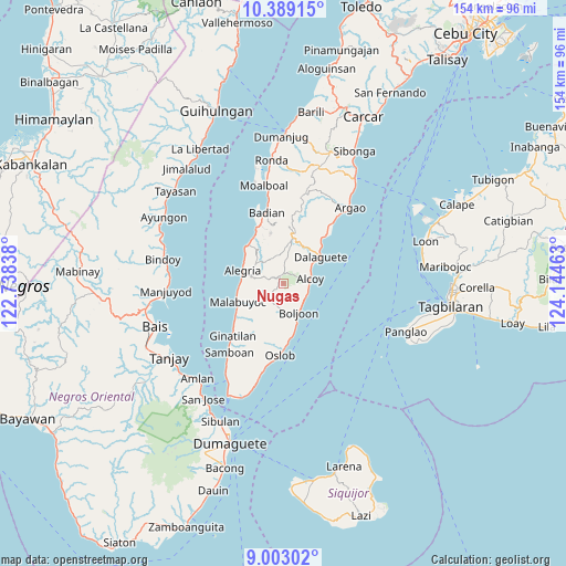
Nugas GPS coordinates[2]
9° 41' 48.48" North, 123° 26' 29.4" East
| Map corner | latitude | longitude |
|---|---|---|
| Upper-left | 10.38915°, | 122.73838° |
| Center: | 9.6968°, | 123.4415° |
| Lower-right: | 9.00302°, | 124.14463° |
| Map W x H: | 154.1×154.1 km | = 95.8×95.8mi |
| max Lat: | 20.78733° ⇑71.6% North |
| Nugas: | 9.6968° |
| min Lat: | ⇓28.4% South 4.65442° |
| min Long | Nugas | max Long |
| 117.04868° | 123.4415° | 126.58417° |
| W 61.1%⇐ | ⇒38.9% E |
Elevation
Elevation of Nugas is 688 m = 2257 ft, and this is 600.1 m = 1969 ft above average elevation for this country.
| Max E: |
2262 m = 7421 ft | 2.6% |
| Nugas | 688 m 2257 ft | |
| Avg. | 87.9 m = 288 ft | |
Min E: |
-2 m = -7 ft | 97.4% |
See also: Philippines elevation on elevation.city.
Geographical zone
Nugas is located in North Torrid zone (between Equator and Tropic of Cancer). Distance of Equator is 1078.2 km =670 mi to South.| Distance of | km | miles | from Nugas |
|---|---|---|---|
| North Pole | 8928.9 | 5548.2 | to North |
| Arctic Circle | 6323 | 3928.9 | to North |
| Tropic Cancer | 1527.7 | 949.3 | to North |
| Equator | 1078.2 | 670 | to South |


Nearby cities:
15 places around Nugas: (largest is in red/bold)
• Alcoy
7.3 km =4.5 mi,  78°
78°
• Alegria
11.7 km =7.3 mi,  287°
287°
• Becerril
4.9 km =3 mi,  189°
189°
• Boljoon
8.6 km =5.3 mi,  152°
152°
• Dalaguete
12.5 km =7.8 mi,  55°
55°
• El Pardo
7.1 km =4.4 mi,  125°
125°
• Guadalupe
5.3 km =3.3 mi,  304°
304°
• Lepanto
4.5 km =2.8 mi,  252°
252°
• Malbug
11.8 km =7.3 mi, 289°
• Montaneza
12.4 km =7.7 mi,  263°
263°
• Obong
9 km =5.6 mi, 56°
• Santa Filomena
12.3 km =7.6 mi, 299°
• Tabon
12.1 km =7.5 mi,  7°
7°
• Tapon
12.5 km =7.8 mi,  48°
48°
• Valencia
11.6 km =7.2 mi,  315°
315°
Sources, notices
• [Note1] Compared only with cities in Philippines existing in our database
• [Src1] Map data: © OpenStreetMap contributors (CC-BY-SA)
• [Src2] Other city data from geonames.org with taken over terms of usage.
• [Src3] Geographical zone / Annual Mean Temperature by Robert A. Rohde @ Wikipedia
