Boljoon geodata
Boljoon (Central Visayas) is a seat of a third-order administrative division; located in Philippines in Asia/Manila (GMT+8) time zone. With population of 3,314 people, there are 2208 cities with bigger population in this country. Compared to other cities in Philippines, 72.3% of cities are located further ↑North; 61.8% of cities are located further ←West and 70.2% of cities have higher elevation than Boljoon. Note1


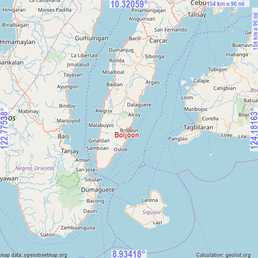
Boljoon GPS coordinates[2]
9° 37' 41.16" North, 123° 28' 42.6" East
| Map corner | latitude | longitude |
|---|---|---|
| Upper-left | 10.32059°, | 122.77538° |
| Center: | 9.6281°, | 123.4785° |
| Lower-right: | 8.93418°, | 124.18163° |
| Map W x H: | 154.2×154.2 km | = 95.8×95.8mi |
| max Lat: | 20.78733° ⇑72.3% North |
| Boljoon: | 9.6281° |
| min Lat: | ⇓27.7% South 4.65442° |
| min Long | Boljoon | max Long |
| 117.04868° | 123.4785° | 126.58417° |
| W 61.8%⇐ | ⇒38.2% E |
Elevation
Elevation of Boljoon is 12 m = 39 ft, and this is 75.9 m = 249 ft below average elevation for this country.
| Max E: |
2262 m = 7421 ft | 70.2% |
| Avg. | 87.9 m = 288 ft | |
| Boljoon | 12 m = 39 ft | |
Min E: |
-2 m = -7 ft | 29.8% |
See also: Philippines elevation on elevation.city.
Geographical zone
Boljoon is located in North Torrid zone (between Equator and Tropic of Cancer). Distance of Equator is 1070.5 km =665.2 mi to South.| Distance of | km | miles | from Boljoon |
|---|---|---|---|
| North Pole | 8936.5 | 5552.9 | to North |
| Arctic Circle | 6330.6 | 3933.7 | to North |
| Tropic Cancer | 1535.4 | 954.1 | to North |
| Equator | 1070.5 | 665.2 | to South |


Nearby cities:
15 places around Boljoon: (largest is in red/bold)
• Alcoy
9.6 km =6 mi,  18°
18°
• Alegria
18.9 km =11.7 mi,  306°
306°
• Becerril
5.6 km =3.5 mi,  299°
299°
• Dalaguete
16 km =9.9 mi, 22°
• El Pardo
4 km =2.5 mi,  26°
26°
• Guadalupe
13.5 km =8.4 mi,  321°
321°
• Lepanto
10.4 km =6.5 mi, 307°
• Malabuyoc
17 km =10.6 mi,  279°
279°
• Malbug
19.1 km =11.9 mi, 307°
• Montaneza
17.6 km =10.9 mi,  290°
290°
• Nugas
8.6 km =5.3 mi,  332°
332°
• Obong
13 km =8.1 mi, 15°
• Oslob
13 km =8.1 mi,  203°
203°
• Talangnan
15.8 km =9.8 mi,  272°
272°
• Tapon
16.8 km =10.4 mi, 18°
Sources, notices
• [Note1] Compared only with cities in Philippines existing in our database
• [Src1] Map data: © OpenStreetMap contributors (CC-BY-SA)
• [Src2] Other city data from geonames.org with taken over terms of usage.
• [Src3] Geographical zone / Annual Mean Temperature by Robert A. Rohde @ Wikipedia
