Alegria geodata
Alegria (Central Visayas) is a seat of a third-order administrative division; located in Philippines in Asia/Manila (GMT+8) time zone. With population of 2,539 people, there are 3228 cities with bigger population in this country. Compared to other cities in Philippines, 71.4% of cities are located further ↑North; 59.2% of cities are located further ←West and 70.2% of cities have higher elevation than Alegria. Note1


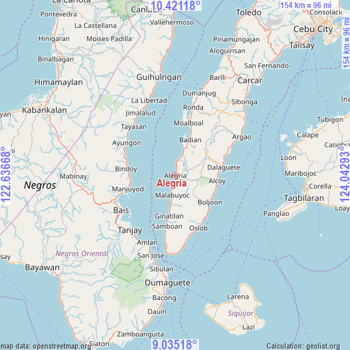
Alegria GPS coordinates[2]
9° 43' 44.04" North, 123° 20' 23.28" East
| Map corner | latitude | longitude |
|---|---|---|
| Upper-left | 10.42118°, | 122.63668° |
| Center: | 9.7289°, | 123.3398° |
| Lower-right: | 9.03518°, | 124.04293° |
| Map W x H: | 154.1×154.1 km | = 95.8×95.8mi |
| max Lat: | 20.78733° ⇑71.4% North |
| Alegria: | 9.7289° |
| min Lat: | ⇓28.6% South 4.65442° |
| min Long | Alegria | max Long |
| 117.04868° | 123.3398° | 126.58417° |
| W 59.2%⇐ | ⇒40.8% E |
Elevation
Elevation of Alegria is 12 m = 39 ft, and this is 75.9 m = 249 ft below average elevation for this country.
| Max E: |
2262 m = 7421 ft | 70.2% |
| Avg. | 87.9 m = 288 ft | |
| Alegria | 12 m = 39 ft | |
Min E: |
-2 m = -7 ft | 29.8% |
See also: Philippines elevation on elevation.city.
Geographical zone
Alegria is located in North Torrid zone (between Equator and Tropic of Cancer). Distance of Equator is 1081.8 km =672.2 mi to South.| Distance of | km | miles | from Alegria |
|---|---|---|---|
| North Pole | 8925.3 | 5545.9 | to North |
| Arctic Circle | 6319.4 | 3926.7 | to North |
| Tropic Cancer | 1524.2 | 947.1 | to North |
| Equator | 1081.8 | 672.2 | to South |


Nearby cities:
15 places around Alegria: (largest is in red/bold)
• Badian
16.3 km =10.1 mi,  22°
22°
• Banhigan
15.5 km =9.6 mi, 20°
• Becerril
13.4 km =8.3 mi,  129°
129°
• Guadalupe
6.8 km =4.2 mi,  94°
94°
• Lepanto
8.5 km =5.3 mi, 125°
• Madridejos
7 km =4.3 mi,  5°
5°
• Malabuyoc
8.6 km =5.3 mi,  190°
190°
• Malbug
0.4 km =0.2 mi, 5°
• Mantalongon
16.2 km =10.1 mi,  55°
55°
• Montaneza
5.1 km =3.2 mi, 193°
• Nugas
11.7 km =7.3 mi,  107°
107°
• Santa Filomena
2.6 km =1.6 mi, 11°
• Tabon
15.3 km =9.5 mi, 56°
• Talangnan
10.6 km =6.6 mi,  183°
183°
• Valencia
5.6 km =3.5 mi,  32°
32°
Sources, notices
• [Note1] Compared only with cities in Philippines existing in our database
• [Src1] Map data: © OpenStreetMap contributors (CC-BY-SA)
• [Src2] Other city data from geonames.org with taken over terms of usage.
• [Src3] Geographical zone / Annual Mean Temperature by Robert A. Rohde @ Wikipedia
