Lepanto geodata
Lepanto (Central Visayas) is a populated place; located in Philippines in Asia/Manila (GMT+8) time zone. With population of 2,472 people, there are 3343 cities with bigger population in this country. Compared to other cities in Philippines, 71.8% of cities are located further ↑North; 60.4% of cities are located further ←West and 96.7% of cities have lower elevation than Lepanto. Note1


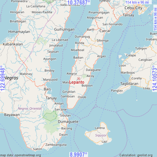
Lepanto GPS coordinates[2]
9° 41' 4.2" North, 123° 24' 9.36" East
| Map corner | latitude | longitude |
|---|---|---|
| Upper-left | 10.37687°, | 122.69948° |
| Center: | 9.6845°, | 123.4026° |
| Lower-right: | 8.9907°, | 124.10573° |
| Map W x H: | 154.1×154.1 km | = 95.8×95.8mi |
| max Lat: | 20.78733° ⇑71.8% North |
| Lepanto: | 9.6845° |
| min Lat: | ⇓28.2% South 4.65442° |
| min Long | Lepanto | max Long |
| 117.04868° | 123.4026° | 126.58417° |
| W 60.4%⇐ | ⇒39.6% E |
Elevation
Elevation of Lepanto is 575 m = 1886 ft, and this is 487.1 m = 1598 ft above average elevation for this country.
| Max E: |
2262 m = 7421 ft | 3.3% |
| Lepanto | 575 m 1886 ft | |
| Avg. | 87.9 m = 288 ft | |
Min E: |
-2 m = -7 ft | 96.7% |
See also: Philippines elevation on elevation.city.
Geographical zone
Lepanto is located in North Torrid zone (between Equator and Tropic of Cancer). Distance of Equator is 1076.8 km =669.1 mi to South.| Distance of | km | miles | from Lepanto |
|---|---|---|---|
| North Pole | 8930.2 | 5549 | to North |
| Arctic Circle | 6324.4 | 3929.8 | to North |
| Tropic Cancer | 1529.1 | 950.1 | to North |
| Equator | 1076.8 | 669.1 | to South |


Nearby cities:
15 places around Lepanto: (largest is in red/bold)
• Alcoy
11.8 km =7.3 mi,  75°
75°
• Alegria
8.5 km =5.3 mi,  305°
305°
• Becerril
4.9 km =3 mi,  135°
135°
• Boljoon
10.4 km =6.5 mi,  127°
127°
• El Pardo
10.4 km =6.5 mi,  105°
105°
• Guadalupe
4.3 km =2.7 mi,  358°
358°
• Madridejos
13.4 km =8.3 mi,  332°
332°
• Malabuyoc
9.2 km =5.7 mi,  247°
247°
• Malbug
8.7 km =5.4 mi, 308°
• Montaneza
8.1 km =5 mi,  270°
270°
• Nugas
4.5 km =2.8 mi,  72°
72°
• Obong
13.3 km =8.3 mi,  61°
61°
• Santa Filomena
9.8 km =6.1 mi,  319°
319°
• Talangnan
9.3 km =5.8 mi,  233°
233°
• Valencia
10.4 km =6.5 mi,  338°
338°
Sources, notices
• [Note1] Compared only with cities in Philippines existing in our database
• [Src1] Map data: © OpenStreetMap contributors (CC-BY-SA)
• [Src2] Other city data from geonames.org with taken over terms of usage.
• [Src3] Geographical zone / Annual Mean Temperature by Robert A. Rohde @ Wikipedia
