El Pardo geodata
El Pardo (Central Visayas) is a populated place; located in Philippines in Asia/Manila (GMT+8) time zone. With population of 2,768 people, there are 2846 cities with bigger population in this country. Compared to other cities in Philippines, 71.9% of cities are located further ↑North; 62% of cities are located further ←West and 50.3% of cities have higher elevation than El Pardo. Note1


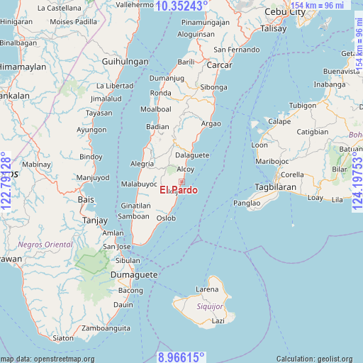
El Pardo GPS coordinates[2]
9° 39' 36" North, 123° 29' 39.84" East
| Map corner | latitude | longitude |
|---|---|---|
| Upper-left | 10.35243°, | 122.79128° |
| Center: | 9.66°, | 123.4944° |
| Lower-right: | 8.96615°, | 124.19753° |
| Map W x H: | 154.1×154.1 km | = 95.8×95.8mi |
| max Lat: | 20.78733° ⇑71.9% North |
| El Pardo: | 9.66° |
| min Lat: | ⇓28.1% South 4.65442° |
| min Long | El Pardo | max Long |
| 117.04868° | 123.4944° | 126.58417° |
| W 62%⇐ | ⇒38% E |
Elevation
Elevation of El Pardo is 23 m = 75 ft, and this is 64.9 m = 213 ft below average elevation for this country.
| Max E: |
2262 m = 7421 ft | 50.3% |
| Avg. | 87.9 m = 288 ft | |
| El Pardo | 23 m = 75 ft | |
Min E: |
-2 m = -7 ft | 49.7% |
See also: Philippines elevation on elevation.city.
Geographical zone
El Pardo is located in North Torrid zone (between Equator and Tropic of Cancer). Distance of Equator is 1074.1 km =667.4 mi to South.| Distance of | km | miles | from El Pardo |
|---|---|---|---|
| North Pole | 8933 | 5550.7 | to North |
| Arctic Circle | 6327.1 | 3931.5 | to North |
| Tropic Cancer | 1531.8 | 951.8 | to North |
| Equator | 1074.1 | 667.4 | to South |


Nearby cities:
15 places around El Pardo: (largest is in red/bold)
• Alcoy
5.7 km =3.5 mi,  13°
13°
• Becerril
6.6 km =4.1 mi,  263°
263°
• Boljoon
4 km =2.5 mi,  206°
206°
• Cawayan
16.5 km =10.3 mi, 14°
• Dalaguete
12.1 km =7.5 mi,  21°
21°
• Guadalupe
12.4 km =7.7 mi,  304°
304°
• Lepanto
10.4 km =6.5 mi,  285°
285°
• Mantalongon
17.1 km =10.6 mi,  347°
347°
• Montaneza
18.3 km =11.4 mi,  278°
278°
• Nugas
7.1 km =4.4 mi,  305°
305°
• Obong
9.2 km =5.7 mi, 10°
• Oslob
16.9 km =10.5 mi,  204°
204°
• Tabon
16.6 km =10.3 mi, 345°
• Talangnan
17.8 km =11.1 mi, 260°
• Tapon
12.9 km =8 mi, 15°
Sources, notices
• [Note1] Compared only with cities in Philippines existing in our database
• [Src1] Map data: © OpenStreetMap contributors (CC-BY-SA)
• [Src2] Other city data from geonames.org with taken over terms of usage.
• [Src3] Geographical zone / Annual Mean Temperature by Robert A. Rohde @ Wikipedia
