Limanancong geodata
Limanancong (Mimaropa) is a populated place; located in Philippines in Asia/Manila (GMT+8) time zone. With population of 4,790 people, there are 1379 cities with bigger population in this country. Compared to other cities in Philippines, 57% of cities are located further ↑North; 98.9% of cities are located further →East and 85.4% of cities have higher elevation than Limanancong. Note1


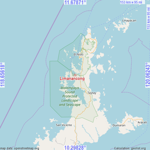
Limanancong GPS coordinates[2]
10° 59' 21.48" North, 119° 21' 33.48" East
| Map corner | latitude | longitude |
|---|---|---|
| Upper-left | 11.67871°, | 118.65618° |
| Center: | 10.9893°, | 119.3593° |
| Lower-right: | 10.29828°, | 120.06243° |
| Map W x H: | 153.5×153.5 km | = 95.4×95.4mi |
| max Lat: | 20.78733° ⇑57% North |
| Limanancong: | 10.9893° |
| min Lat: | ⇓43% South 4.65442° |
| min Long | Limanancong | max Long |
| 117.04868° | 119.3593° | 126.58417° |
| W 1.1%⇐ | ⇒98.9% E |
Elevation
Elevation of Limanancong is 8 m = 26 ft, and this is 79.9 m = 262 ft below average elevation for this country.
| Max E: |
2262 m = 7421 ft | 85.4% |
| Avg. | 87.9 m = 288 ft | |
| Limanancong | 8 m = 26 ft | |
Min E: |
-2 m = -7 ft | 14.6% |
See also: Philippines elevation on elevation.city.
Geographical zone
Limanancong is located in North Torrid zone (between Equator and Tropic of Cancer). Distance of Equator is 1221.9 km =759.3 mi to South.| Distance of | km | miles | from Limanancong |
|---|---|---|---|
| North Pole | 8785.2 | 5458.9 | to North |
| Arctic Circle | 6179.3 | 3839.6 | to North |
| Tropic Cancer | 1384 | 860 | to North |
| Equator | 1221.9 | 759.3 | to South |


Nearby cities:
15 places around Limanancong: (largest is in red/bold)
• Alemanguan
42.1 km =26.2 mi,  184°
184°
• Bato
22 km =13.7 mi,  146°
146°
• Calauag
42.5 km =26.4 mi, 147°
• Casian
39 km =24.2 mi,  82°
82°
• Dumaran
68.2 km =42.4 mi,  139°
139°
• El Nido
22.2 km =13.8 mi,  10°
10°
• Guinlo
22.7 km =14.1 mi,  157°
157°
• New Agutaya
47.9 km =29.8 mi,  186°
186°
• Pancol
14.5 km =9 mi, 154°
• Port Barton
58.4 km =36.3 mi, 192°
• Roxas
74.3 km =46.2 mi, 181°
• San Vicente
52.3 km =32.5 mi, 192°
• Taytay
24.4 km =15.2 mi, 141°
• Tiniguiban
43.9 km =27.3 mi,  21°
21°
• Tumarbong
69 km =42.9 mi,  171°
171°
Sources, notices
• [Note1] Compared only with cities in Philippines existing in our database
• [Src1] Map data: © OpenStreetMap contributors (CC-BY-SA)
• [Src2] Other city data from geonames.org with taken over terms of usage.
• [Src3] Geographical zone / Annual Mean Temperature by Robert A. Rohde @ Wikipedia
