Navotas geodata
Navotas (Calabarzon) is a populated place; located in Philippines in Asia/Manila (GMT+8) time zone. With population of 3,220 people, there are 2286 cities with bigger population in this country. Compared to other cities in Philippines, 73.6% of cities are located further ↓South; 71.2% of cities are located further →East and 59.5% of cities have lower elevation than Navotas. Note1


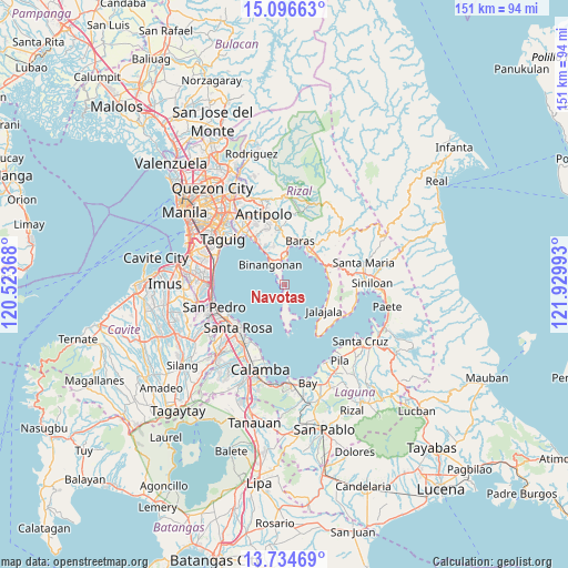
Navotas GPS coordinates[2]
14° 25' 0.12" North, 121° 13' 36.48" East
| Map corner | latitude | longitude |
|---|---|---|
| Upper-left | 15.09663°, | 120.52368° |
| Center: | 14.4167°, | 121.2268° |
| Lower-right: | 13.73469°, | 121.92993° |
| Map W x H: | 151.4×151.4 km | = 94.1×94.1mi |
| max Lat: | 20.78733° ⇑26.4% North |
| Navotas: | 14.4167° |
| min Lat: | ⇓73.6% South 4.65442° |
| min Long | Navotas | max Long |
| 117.04868° | 121.2268° | 126.58417° |
| W 28.8%⇐ | ⇒71.2% E |
Elevation
Elevation of Navotas is 33 m = 108 ft, and this is 54.9 m = 180 ft below average elevation for this country.
| Max E: |
2262 m = 7421 ft | 40.5% |
| Avg. | 87.9 m = 288 ft | |
| Navotas | 33 m = 108 ft | |
Min E: |
-2 m = -7 ft | 59.5% |
See also: Philippines elevation on elevation.city.
Geographical zone
Navotas is located in North Torrid zone (between Equator and Tropic of Cancer). Distance of this Northern Tropic circle is 1002.9 km =623.2 mi to North.| Distance of | km | miles | from Navotas |
|---|---|---|---|
| North Pole | 8404.1 | 5222.1 | to North |
| Arctic Circle | 5798.2 | 3602.8 | to North |
| Tropic Cancer | 1002.9 | 623.2 | to North |
| Equator | 1603 | 996.1 | to South |


Nearby cities:
15 places around Navotas: (largest is in red/bold)
• Angono
14.5 km =9 mi,  327°
327°
• Aplaya
16.2 km =10.1 mi,  228°
228°
• Baras
11.9 km =7.4 mi,  20°
20°
• Binangonan
6.5 km =4 mi, 325°
• Cardona
7.8 km =4.8 mi,  0°
0°
• Gulod
8 km =5 mi,  186°
186°
• Jalajala
12.5 km =7.8 mi,  124°
124°
• Malaya
12.2 km =7.6 mi,  100°
100°
• Morong
11.4 km =7.1 mi,  5°
5°
• Pililla
11.5 km =7.1 mi,  48°
48°
• Punta
16.4 km =10.2 mi,  148°
148°
• Quisao
11.8 km =7.3 mi,  80°
80°
• Santa Rosa
17 km =10.6 mi, 226°
• Tanay
10.9 km =6.8 mi,  34°
34°
• Teresa
16.1 km =10 mi,  357°
357°
Sources, notices
• [Note1] Compared only with cities in Philippines existing in our database
• [Src1] Map data: © OpenStreetMap contributors (CC-BY-SA)
• [Src2] Other city data from geonames.org with taken over terms of usage.
• [Src3] Geographical zone / Annual Mean Temperature by Robert A. Rohde @ Wikipedia
