Santa Rosa geodata
Santa Rosa (Calabarzon) is a seat of a third-order administrative division; located in Philippines in Asia/Manila (GMT+8) time zone. With population of 216,650 people, there are 49 cities with bigger population in this country. Compared to other cities in Philippines, 73% of cities are located further ↓South; 73.5% of cities are located further →East and 67.4% of cities have higher elevation than Santa Rosa. Note1
Administrative division(s):
- Level 1: Calabarzon
- Level 2: Province of Laguna
- Level 3: City of Santa Rosa


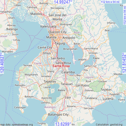
Santa Rosa GPS coordinates[2]
14° 18' 43.992" North, 121° 6' 41.004" East
| Map corner | latitude | longitude |
|---|---|---|
| Upper-left | 14.99247°, | 120.40827° |
| Center: | 14.31222°, | 121.11139° |
| Lower-right: | 13.6299°, | 121.81452° |
| Map W x H: | 151.5×151.5 km | = 94.1×94.1mi |
| max Lat: | 20.78733° ⇑27% North |
| Santa Rosa: | 14.31222° |
| min Lat: | ⇓73% South 4.65442° |
| min Long | Santa Rosa | max Long |
| 117.04868° | 121.11139° | 126.58417° |
| W 26.5%⇐ | ⇒73.5% E |
Elevation
Elevation of Santa Rosa is 13 m = 43 ft, and this is 74.9 m = 246 ft below average elevation for this country.
| Max E: |
2262 m = 7421 ft | 67.4% |
| Avg. | 87.9 m = 288 ft | |
| Santa Rosa | 13 m = 43 ft | |
Min E: |
-2 m = -7 ft | 32.6% |
See also: Santa Rosa elevation on elevation.city.
Geographical zone
Santa Rosa is located in North Torrid zone (between Equator and Tropic of Cancer). Distance of this Northern Tropic circle is 1014.5 km =630.4 mi to North.| Distance of | km | miles | from Santa Rosa |
|---|---|---|---|
| North Pole | 8415.7 | 5229.3 | to North |
| Arctic Circle | 5809.8 | 3610 | to North |
| Tropic Cancer | 1014.5 | 630.4 | to North |
| Equator | 1591.4 | 988.8 | to South |


Nearby cities:
15 places around Santa Rosa: (largest is in red/bold)
• Aplaya
1 km =0.6 mi,  14°
14°
• Biñan
4.7 km =2.9 mi,  315°
315°
• Bulihan
13.1 km =8.1 mi,  253°
253°
• Cabuyao
4.7 km =2.9 mi,  160°
160°
• Calamba
12.6 km =7.8 mi,  152°
152°
• Carmona
5.8 km =3.6 mi,  271°
271°
• Gulod
12 km =7.5 mi,  72°
72°
• Magsaysay
8.8 km =5.5 mi,  289°
289°
• Maguyam
12.7 km =7.9 mi,  244°
244°
• Mamatid
10 km =6.2 mi, 149°
• Muntinlupa
11.1 km =6.9 mi, 321°
• Prinza
13.2 km =8.2 mi,  167°
167°
• Pulong Santa Cruz
5.7 km =3.5 mi,  220°
220°
• Puting Kahoy
13.8 km =8.6 mi, 218°
• San Pedro
8.7 km =5.4 mi,  307°
307°
Sources, notices
• [Note1] Compared only with cities in Philippines existing in our database
• [Src1] Map data: © OpenStreetMap contributors (CC-BY-SA)
• [Src2] Other city data from geonames.org with taken over terms of usage.
• [Src3] Geographical zone / Annual Mean Temperature by Robert A. Rohde @ Wikipedia
