Teresa geodata
Teresa (Calabarzon) is a seat of a third-order administrative division; located in Philippines in Asia/Manila (GMT+8) time zone. With population of 34,716 people, there are 244 cities with bigger population in this country. Compared to other cities in Philippines, 74.4% of cities are located further ↓South; 71.3% of cities are located further →East and 67.1% of cities have lower elevation than Teresa. Note1


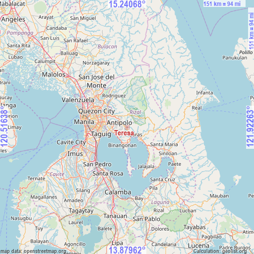
Teresa GPS coordinates[2]
14° 33' 40.32" North, 121° 13' 10.2" East
| Map corner | latitude | longitude |
|---|---|---|
| Upper-left | 15.24068°, | 120.51638° |
| Center: | 14.5612°, | 121.2195° |
| Lower-right: | 13.87962°, | 121.92263° |
| Map W x H: | 151.3×151.3 km | = 94×94mi |
| max Lat: | 20.78733° ⇑25.6% North |
| Teresa: | 14.5612° |
| min Lat: | ⇓74.4% South 4.65442° |
| min Long | Teresa | max Long |
| 117.04868° | 121.2195° | 126.58417° |
| W 28.7%⇐ | ⇒71.3% E |
Elevation
Elevation of Teresa is 46 m = 151 ft, and this is 41.9 m = 137 ft below average elevation for this country.
| Max E: |
2262 m = 7421 ft | 32.9% |
| Avg. | 87.9 m = 288 ft | |
| Teresa | 46 m = 151 ft | |
Min E: |
-2 m = -7 ft | 67.1% |
See also: Philippines elevation on elevation.city.
Geographical zone
Teresa is located in North Torrid zone (between Equator and Tropic of Cancer). Distance of this Northern Tropic circle is 986.9 km =613.2 mi to North.| Distance of | km | miles | from Teresa |
|---|---|---|---|
| North Pole | 8388 | 5212.1 | to North |
| Arctic Circle | 5782.1 | 3592.8 | to North |
| Tropic Cancer | 986.9 | 613.2 | to North |
| Equator | 1619.1 | 1006.1 | to South |


Nearby cities:
15 places around Teresa: (largest is in red/bold)
• Angono
8.1 km =5 mi,  241°
241°
• Antipolo
12.7 km =7.9 mi,  304°
304°
• Baras
7 km =4.3 mi,  134°
134°
• Binangonan
11.1 km =6.9 mi,  194°
194°
• Cainta
10.6 km =6.6 mi,  280°
280°
• Calumpang
15.6 km =9.7 mi, 296°
• Cardona
8.4 km =5.2 mi,  174°
174°
• Morong
5.1 km =3.2 mi,  157°
157°
• Pateros
16 km =9.9 mi,  261°
261°
• Pililla
12.6 km =7.8 mi, 132°
• Pinugay
6.1 km =3.8 mi,  49°
49°
• Sampaloc
15.3 km =9.5 mi,  98°
98°
• Taguig
15.6 km =9.7 mi,  254°
254°
• Tanay
10 km =6.2 mi,  135°
135°
• Taytay
9.3 km =5.8 mi,  268°
268°
Sources, notices
• [Note1] Compared only with cities in Philippines existing in our database
• [Src1] Map data: © OpenStreetMap contributors (CC-BY-SA)
• [Src2] Other city data from geonames.org with taken over terms of usage.
• [Src3] Geographical zone / Annual Mean Temperature by Robert A. Rohde @ Wikipedia
