Morong geodata
Morong (Calabarzon) is a seat of a third-order administrative division; located in Philippines in Asia/Manila (GMT+8) time zone. With population of 49,589 people, there are 177 cities with bigger population in this country. Compared to other cities in Philippines, 74.2% of cities are located further ↓South; 71% of cities are located further →East and 85.4% of cities have higher elevation than Morong. Note1


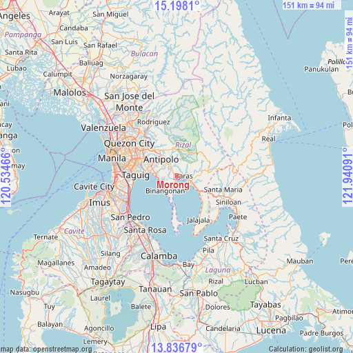
Morong GPS coordinates[2]
14° 31' 6.564" North, 121° 14' 16.008" East
| Map corner | latitude | longitude |
|---|---|---|
| Upper-left | 15.1981°, | 120.53466° |
| Center: | 14.51849°, | 121.23778° |
| Lower-right: | 13.83679°, | 121.94091° |
| Map W x H: | 151.4×151.4 km | = 94.1×94.1mi |
| max Lat: | 20.78733° ⇑25.8% North |
| Morong: | 14.51849° |
| min Lat: | ⇓74.2% South 4.65442° |
| min Long | Morong | max Long |
| 117.04868° | 121.23778° | 126.58417° |
| W 29%⇐ | ⇒71% E |
Elevation
Elevation of Morong is 8 m = 26 ft, and this is 79.9 m = 262 ft below average elevation for this country.
| Max E: |
2262 m = 7421 ft | 85.4% |
| Avg. | 87.9 m = 288 ft | |
| Morong | 8 m = 26 ft | |
Min E: |
-2 m = -7 ft | 14.6% |
See also: Morong elevation on elevation.city.
Geographical zone
Morong is located in North Torrid zone (between Equator and Tropic of Cancer). Distance of this Northern Tropic circle is 991.6 km =616.2 mi to North.| Distance of | km | miles | from Morong |
|---|---|---|---|
| North Pole | 8392.8 | 5215 | to North |
| Arctic Circle | 5786.9 | 3595.8 | to North |
| Tropic Cancer | 991.6 | 616.2 | to North |
| Equator | 1614.3 | 1003.1 | to South |


Nearby cities:
15 places around Morong: (largest is in red/bold)
• Angono
9.1 km =5.7 mi,  275°
275°
• Antipolo
17.2 km =10.7 mi,  313°
313°
• Baras
3 km =1.9 mi,  93°
93°
• Binangonan
7.7 km =4.8 mi,  218°
218°
• Cainta
14.1 km =8.8 mi,  298°
298°
• Cardona
3.7 km =2.3 mi,  197°
197°
• Navotas
11.4 km =7.1 mi,  185°
185°
• Pililla
8.2 km =5.1 mi,  116°
116°
• Pinugay
9.1 km =5.7 mi,  16°
16°
• Quisao
14 km =8.7 mi,  131°
131°
• Sampaloc
13.4 km =8.3 mi,  79°
79°
• Taguig
17.1 km =10.6 mi,  272°
272°
• Tanay
5.6 km =3.5 mi, 115°
• Taytay
12.2 km =7.6 mi,  291°
291°
• Teresa
5.1 km =3.2 mi,  337°
337°
Sources, notices
• [Note1] Compared only with cities in Philippines existing in our database
• [Src1] Map data: © OpenStreetMap contributors (CC-BY-SA)
• [Src2] Other city data from geonames.org with taken over terms of usage.
• [Src3] Geographical zone / Annual Mean Temperature by Robert A. Rohde @ Wikipedia
